
Yero Beri Kunda
| Yero Beri Kunda | ||
|---|---|---|
|
Coordinates: 13 ° 30 ′ N , 14 ° 45 ′ W |
||
| Region: | Central River | |
| District: | Fulladu West | |
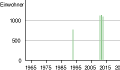
| Residents: | 1078 (2013)
|
|
|
||

Yero Beri Kunda (spelling variants: Youo Beri Kunda and Yoro Beri Kunda ; name variants: Yero Beri Kunda Agricultural Station , Yero Beri Kunda Fula and Yero Beri Kunda Mandinka ) is a town in the West African state of Gambia .
According to a calculation for 2013, there are around 1078 inhabitants, the result of the last published census from 1993 was 909.
geography
Yero Beri Kunda is located on the southern bank of the Gambia River in the Central River Region , Fulladu West District . The place is located directly on the South Bank Road , Gambia's most important trunk road. On this road, Yero Beri Kunda is located between Fula Bantang and Bansang around 8.5 kilometers east of Fula Bantang. Sankulay Kunda is 2.2 kilometers away , on a road that branches off north to Janjanbureh .
See also
Individual evidence
- ↑ Yero Beri Kunda on bevoelkerungsstatistik.de (no longer available online, last accessed May 2013)