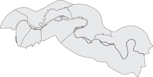
Central River Region
| map | |
|---|---|
 Location of the region in Gambia Location of the region in Gambia
|
|
 Central River Region Central River Region
|
|
| Basic data | |
| Administrative location | Janjanbureh |
| Districts | 10 |
| Geographical center | 13 ° 34 ′ N , 14 ° 58 ′ W |
| North South expansion | 57 km |
| East-west expansion | 110 km |
| surface | 2,895 km² |
| population | 207,574 (as of 2013) |
| Population density | 72 inhabitants / km² |
| ISO 3166-2 |
GM-M
|
| Telephone code | (+220) 5 |
The Central River Region (formerly: Central River Division ) is one of six administrative units of the West African state of Gambia . The region corresponds to the Local Government Area Janjanbureh and Local Government Area Kuntaur .
geography
The 2895 km² region, with the seat of the administrative unit in Janjanbureh (3998 inhabitants), is further divided into ten districts . With 207,574 inhabitants (2013 calculation) the division extends to both banks of the Gambia River . Bordering the Lower River Region in the west and the North Bank Region to the Upper River Region in the east. The seat of the administrative unit in Janjanbureh is on the island of Janjanbureh Island , which forms its own district Janjanbureh . The largest town is Bansang in the Fulladu West district with 8535 inhabitants .
Districts
The ten districts are: Lower Saloum , Upper Saloum , Nianija , Niani , Sami , Niamina Dankunku , Niamina West , Niamina East , Fulladu West and Janjanbureh .
Localities
The ten largest places are:
- Bansang , 8535
- Brikama Ba , 4204
- Janjanbureh , 3998
- Madina Umfally , 3145
- Kuntaur , 3074
- Sami , 3040
- Jarreng , 3037
- Kundang , 2555
- Kerewan Samba Sira , 2283
- Saruja , 2196
population
According to a survey from 1993 ( census at that time ), the Mandinka represented the largest population group with a share of around three-tenths, followed by the Fula and the Wolof. The distribution in detail: 29.5% Mandinka , 37.2% Fula , 26% Wolof , 0.6% Jola , 4.1% Serahule , 0.4% Serer , 0.1% Aku , 0.3% Manjago , 0.6% Bambara and 1.2% other races.
history
As part of the Africanization , the former name MacCarthy Island was renamed Central River Division in 1995. MacCarthy Island was renamed Janjanbureh Island and the administrative capital Georgetown was renamed Janjanbureh.
At the end of 2007, as part of an administrative reform, the former Central River Division became the Central River Region .
|

|
politics
The administrative unit is headed by a governor; Sheriff Abba Sanyang has held this position since March 2019 .
Individual evidence
- ↑ Central River Region on bevoelkerungsstatistik.de (no longer available online, last accessed May 2013)
- ^ Population by Ethnicity, by Settlement and Local Government Area. (Gambians Only) ( Memento from November 13, 2012 in the Internet Archive ) PDF file