Janjanbureh
| Janjanbureh | ||
|---|---|---|
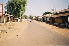
| A street in Janjanbureh | ||
|
Coordinates: 13 ° 32 ′ N , 14 ° 46 ′ W |
||
| Region: | Central River | |
| District: | Janjanbureh | |
| Founding: | 1832 | |
| Residents: | 3998 (2013)
|
|

|
||
| Climate diagram for Janjanbureh | ||
Janjanbureh (spelling variants: Jangjangbureh , Janjangbureh or Janjangbure ; formerly Georgetown ) is the seat of the Central River Region administrative unit in the West African state of Gambia .
According to a calculation for 2013, there are around 3998 inhabitants, the result of the last published census from 1993 was 2813.
geography
Janjanbureh is located on Janjanbureh Island in the Gambia Current on the northern edge of the island and is the capital of the Central River Region administrative unit , it forms its own district Janjanbureh . It is located in central Gambia, 283 kilometers upstream from the capital Banjul and is approximately eleven kilometers long and two and a half kilometers wide.
history
The island on which the city is located today was taken over by Captain Alexander Grant of the Royal African Corps in 1823 to establish the Fort George branch for freed slaves. The island was renamed MacCarthy Island in honor of the Governor General of British West Africa , Sir Charles MacCarthy (1814–24) . MacCarthy himself was a fighter against the slave trade .
In the 1830s, due to the favorable location around the Wesleyan Mission, a transshipment point for peanuts , rice and other agricultural products developed, which were then shipped further downstream to Banjul. Due to the brisk trade, the city was created, which was named in honor of King George IV. Georgetown .
In 1995 the city was renamed Janjanbureh. Likewise, as part of the Africanization, the island of MacCarthy Island was renamed Janjanbureh Island .
traffic
The Janjanbureh – Lamin Koto ferry connection is located on the northern shore of the island .
Culture and sights
- The Wassu stone circles are about 15 km northwest of Janjanbureh.
- The Mungo Park Memorial at Karantaba Tenda , approx. 28 km east of Janjanbureh.
- The Kankurang Center and Museum , since 2016
- The Kankurang Festival , which has been taking place again in the second half of January since 2018.
Sons and daughters of the place
- Farimang Singhateh (1912–1977), pharmacist and politician
- Foday Jibani Manka (1942–2014), politician
See also
Individual evidence
- ↑ Janjanbureh on bevoelkerungsstatistik.de (no longer available online, last accessed May 2013)
literature
- Thomas Baur: Senegal, Gambia: Discover, experience and enjoy Senegambia and the Bijagos Archipelago with this practical holiday guide . Reise Know-How Verlag Rump, Bielefeld 2002, ISBN 3-8317-1112-7 .


