
Karantaba (Jarra West)
| Karantaba | ||
|---|---|---|
|
Coordinates: 13 ° 26 ′ N , 15 ° 31 ′ W |
||
| Region: | Lower River | |
| District: | Jarra West | |
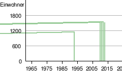
| Residents: | 1490 (2013)
|
|
|
||

Karantaba is a town in the West African state of Gambia .
According to a calculation for 2013, around 1490 inhabitants live there, the result of the last published census from 1993 was 1135.
geography
Karantaba is located in the Lower River Region in Jarra West District , around 2.3 kilometers west of Soma on the South Bank Road . Kani Kunda is 1.3 kilometers to the northwest.
Culture and sights
According to a listing by the National Center for Arts & Culture , Karantaba was a location of a tattoo .
See also
Individual evidence
- ↑ Karantaba (Jarra West) on bevoelkerungsstatistik.de (no longer available online, last accessed May 2013)
- ↑ Allen Meagher (ed.): Historic sites of The Gambia. Ada Dinkiralu (Mandinka), Bereb-I-Chosan (Wolof), Tarica Tawal (Fula), Nannin (Jola), Soninke Ada (Serehuli), I-Mofan Chosan (Serer). An official guide to the monuments and sites of The Gambia. National Council for the Arts and Culture, Banjul The Gambia 1998, ISBN 9983-80-011-014 .