
Serrekunda
| Serrekunda | ||
|---|---|---|
|
Coordinates: 13 ° 26 ′ N , 16 ° 41 ′ W |
||
| Region: | Greater Banjul Area | |
| Next place: | Banjul , Abuko | |
| Residents: | 362,986 (2013)
|
|
 |
||

|
||
 |
||
 |
||
 |
||

Serekunda (spelling variants: Serrekunda or Sere Kunda ) is the largest city in the West African state of Gambia .
According to a calculation for 2013, there are 362,986 inhabitants, the result of the last published census from 1993 was 70,435.
geography
With just under 350,000 inhabitants, Serekunda belongs to the Kombo-St. Mary Area and is located south of the mouth of the Gambia River on the Atlantic Ocean and around eleven kilometers west of the capital Banjul and north of Banjul Airport .
Districts
Formerly listed as individual settlements in the 1993 census, the following places can now be understood as districts of Serekunda: Bakoteh , Bununka Kunda , Dippa Kunda , Eboe Town , Faji Kunda , New Jeshwang , Old Jeshwang , Kololi , Kotu , Latri Kunda , Latri Kunda Sabiji , Manjai Kunda , Serekunda , Talinding Kunjang .
Other districts are Kanifing , London Corner , Tabokoto and Bundung .
|

history
The city was probably founded by Portuguese colonialists in the 17th century , and in the 18th / 19th century. Expanded by the British in the 19th century .
Service center
As the most important market and trade center, Serrekunda is of great importance for the whole of Gambia. Due to its favorable location, the city soon developed into a center of the region. After independence, several authorities were set up in Serekunda. International embassies, such as those of the USA and Brazil , have their headquarters here. The district of Kanifing is the location of the University of Gambia, founded in 1998 .

At the edge of the market in July 1999, a baobab can be seen in the middle
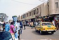
The market halls in Serekunda

Mosque in Serrekunda


Culture and sights
- Pipeline Mosque , the main mosque in the city
- Trinity Methodist Church , the city's Methodist church
- St Charles Lwanga Church , the city's Roman Catholic Church
Town twinning
-
 United States , Memphis ( Kanifing )
sons and daughters of the town
Sorted chronologically:
- Momodou Nai Ceesay (* 1951), politician
- Halifa Sallah (* 1953), politician
- Tijan Sallah (* 1958), poet
- Njogu Touray (* 1960), painter
- Musa Mboob (* 1963), musician
- Angela Colley (* 1964), politician
- Sadibou Hydara (1964–1995), politician
- Ousman Sonko (* 1969), politician
- Kemo Ceesay (* 1971), football player
- Jatto Ceesay (* 1974), football player
- Dembo Jobarteh (1976-2008), musician
- Mamadou Danso (born 1983), football player
- Matthew Mendy (born 1983), soccer player
- Yankuba Ceesay (* 1984), football player
- Ismaila Jagne (* 1984), football player
- Pa Saikou Kujabi (* 1986), football player
- Ebrahima Sawaneh (* 1986), football player
- Saloum Faal (* 1994), football player
- Maudo Jarjué (* 1997), Guinea-Bissau football player
See also
Individual evidence
- ↑ Serrekunda on bevoelkerungsstatistik.de (no longer available online, last accessed May 2013)
- ↑ 1993 census ( Memento of the original from April 12, 2013 in the Internet Archive ) Info: The archive link was inserted automatically and not yet checked. Please check the original and archive link according to the instructions and then remove this notice. PDF file , accessed June 2010
Web links
- Road map of the area ( memento of September 29, 2007 in the Internet Archive )