Brikama
| Brikama | ||
|---|---|---|
|
Coordinates: 13 ° 16 ′ N , 16 ° 39 ′ W |
||
| Region: | West coast | |
| District: | Combo Central | |
| Residents: | 84,608 (2013)
|
|
| Map of Brikama | ||

|
||
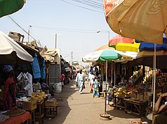
| The market in Brikama | ||
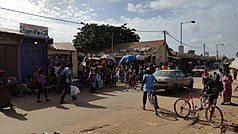
| Main street (Nyambai Road) in the center of Brikama | ||
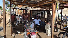
| Simplest motorcycle workshop on the main street (Nyambai Road) in the center | ||
Brikama is the second largest city in the West African state of Gambia and the capital of the West Coast Region administrative unit .
According to a calculation for 2013, around 84,608 inhabitants live there, the result of the last published census from 1993 was 42,480.
geography
Brikama is located on the important southern trunk road, the South Bank Road , which begins in Brikama and crosses the country to Basse Santa Su (approx. 360 km). It is the continuation of the Brikama Highway , which ends in Brikama. This road comes from the north from the capital Banjul (approx. 36 km) via Serekunda (approx. 21 km) and passes the Banjul International Airport , approx. Six kilometers from Brikama.
To distinguish it from the much smaller town of Brikama Ba , in the Central River Region , Brikama is often called Brikama-Kombo, which refers to the former Kingdom of Kombo , which used to be here in what is now the West Coast Region .
politics
Town twinning
-
 Senegal , Joal-Fadiouth
-
 Senegal , Grand Yoff (Dakar) with (Brikama Area Council), 2007
Culture and sights
Brikama is known for wood carvings that are sold in the market. The place is also the center of the musical culture of Gambia.
Place of worship
In Brikama, a sacred tree is known as a place of worship under the name of Santanba .
Economy and Infrastructure
Established businesses
The Gambia's first independent electricity supplier operates the Brikama thermal power station in Brikama .
education
The Gambia College is located in Brikama .
sons and daughters of the town
- Bai Konte (1920–1983), musician
- Fatoumata Tambajang (* 1949), politician
- Lamin Bojang (* 1952), politician
- Ousman Jammeh (* 1953), politician
- Lamin Kaba Bajo (* 1964), politician
- Tata Dindin (* 1965), musician
- Omar Jatta (* 1989), football player
See also
Individual evidence
- ↑ Brikama on bevoelkerungsstatistik.de (no longer available online, last accessed May 2013)
- ^ BAC-Grand Yoff Municipalities Twin-Up The Daily Observer of September 7, 2007
- ↑ Allen Meagher (ed.): Historic sites of The Gambia. Ada Dinkiralu (Mandinka), Bereb-I-Chosan (Wolof), Tarica Tawal (Fula), Nannin (Jola), Soninke Ada (Serehuli), I-Mofan Chosan (Serer). An official guide to the monuments and sites of The Gambia. National Council for the Arts and Culture, Banjul The Gambia 1998, ISBN 9983-80-011-014 .


