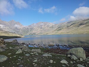
Gangbal Lake
| Gangbal Lake | ||
|---|---|---|

|
||
| Geographical location | Jammu and Kashmir ( India ) | |
| Drain | → Are | |
| Data | ||
| Coordinates | 34 ° 25 '58 " N , 74 ° 55' 20" E | |
|
|
||
| Altitude above sea level | 3566 m | |
| surface | 1.67 km² | |
| length | 2.7 km | |
| width | 950 m | |
| scope | 6.37 km | |
The Gangbal Lake (also Gangabal Lake ) is a mountain lake in the western Himalayas in the Indian union territory of Jammu and Kashmir .
The lake is located 40 km north-northeast of Srinagar in the Ganderbal district . The lake, located at 3566 m above sea level, covers an area of 167 hectares. It is located on the northern flank of the 5142 m high glaciated mountain Haramukh . The lake is drained at its eastern end to Nundkol Lake to the south and further over the Wangath Nallah to Sind . Gangbal Lake is a tourist destination. The lake surface freezes in the months of November to April.
Web links
Commons : Gangbal Lake - Collection of Images, Videos and Audio Files
Individual evidence
- ↑ a b c National Wetland Atlas: High Altitude Lakes Of India (PDF (8.66 MB)) Space Applications Center, ISRO, Government of India. Sept 2012.
