Ganderbal (District)
| Ganderbal District | |
|---|---|

|
|
| Union Territory | Jammu and Kashmir |
| Division : | Kashmir |
| Administrative headquarters : | Ganderbal |
| Area : | 1045 km² |
| Residents : | 297,446 (2011) |
| Population density : | 285 inhabitants / km² |
| Website : | ganderbal.nic.in |
Ganderbal is a district in the Union Territory of Jammu and Kashmir , India .
The district was formed in 2007 from two Tehsils ( Ganderbal and Kangan ) from the Srinagar district.
geography
The district of Ganderbal lies at an average altitude of 1950 m . The administrative center of Ganderbal is approximately 21 km from Srinagar.
The Sind flows through the district. There are three hydropower plants on this river and it supplies the population of the district with water. 80% of the population live from agriculture and the river's water is also used to irrigate the fields. The river's sand is valued as a building material and is sold.
Administrative division
The district consists of 6 Tehsils: Ganderbal, Gund, Kangan, Lar, Tullamulla and Wakura. The district also consists of 9 blocks: Ganderbal, Kangan, Lar, Wakoora, Gund, Shearpathri, Phaag, Manigam and Batwina. Each block consists of a series of panchayats . The district has two constituencies.
climate
The climate of the Ganderbal district is typical of the Kashmir Valley .
tourism
- The Naranag temples are a significant archaeological site. The temples are located at the foot of Haramukh about 50 km from Srinagar . They are said to be dedicated to Shiva and go back to the ruler Lalithdatiya Muktadiya from the eighth century.
- The Hill Station Sonamarg is located in the Ganderbal district. Sonmarg is a popular excursion destination for hikes and is known as the setting from many Bollywood films .
- The Manasbal Lake is 12 km northwest of Ganderbal. The Garoka Garden, laid out for Nur Jahan , is located on this lake. The lake offers good bird watching opportunities . Lotus roots from the lake are harvested, eaten and sold by locals.
- Mount Haramukh ( 5148 m ) is located in the Ganderbal district. Climbing the mountain from this side is considered very dangerous. The Haramukh was first climbed by the Great Trigonometric Survey under Thomas Montgomerie in 1856. The K1 and K2 were first recorded and named from its summit .
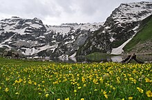
- The Gangabal Lake ( Urdu -ﮔﻨﮕﺒﻞ ﺟﮭﻴﻞ), also called Gangbal Lake , is located at the foot of Haramukh. It is a mountain lake rich in fish.
Web links
Individual evidence
- ^ Agriculture directory of Ganderbal . diragrikmr.nic. Archived from the original on January 21, 2013. Info: The archive link was automatically inserted and has not yet been checked. Please check the original and archive link according to the instructions and then remove this notice. Retrieved April 25, 2012.
- ↑ ERO's and AERO’s . Chief Electoral Officer, Jammu and Kashmir. Archived from the original on October 22, 2008. Retrieved April 24, 2012.
- ↑ Naranag temple in ruins . kashmirmonitor.org. Archived from the original on August 4, 2012. Retrieved April 25, 2012.
- ↑ Mansbal Lake ( Memento of February 14, 2012 in the Internet Archive ) on indiainfoweb.com. (Web archive)
- ↑ Manasbal Lake ( memento of March 3, 2012 in the Internet Archive ) on ilec.or.jp
- ^ Kashmir Lakes
- ↑ Manasbal Lake
- ↑ Jim Curran: K2. The Story of the Savage Mountain . Hodder & Stoughton, London 1995, ISBN 0-340-66007-4 , pp. 25 .
- ^ Fishes and Fisheries in high altitude lakes, Vishansar, Gadsar, Gangabal, Krishansar . Fao.org. Retrieved April 19, 2012.
- ^ T. Petr: Fish and fisheries at higher altitudes: Asia . FAO, Rome 1999, ISBN 92-5104309-4 , pp. 72 ( books.google.com ).
Coordinates: 34 ° 8 ' N , 74 ° 28' E

