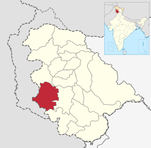
Rajouri (district)
| Rajouri District | |
|---|---|

|
|
| Union Territory | Jammu and Kashmir |
| Division : | Jammu |
| Administrative headquarters : | Rajouri |
| Area : | 2630 km² |
| Residents : | 642,415 (2011) |
| Population density : | 244 inhabitants / km² |
| Website : | http://rajouri.nic.in/ |
Rajouri is a district in the Indian Union Territory of Jammu and Kashmir .
The Line of Control lies in the west of the district and in the north the Punch district borders on Rajouri. The administrative seat is Rajouri .
The soil is fertile. Corn and rice are the main products of agriculture. The Nowshera Tawi , which rises in Pir Panjal , flows through the district.
administration
The district consists of the Tehsils : Rajouri, Darhal sunderbani, Koteranka, Nowshera, Thannamandi and Kalakot and nine blocks. Each block consists of a series of panchayats .
The district has four constituencies: Nowshera, Darhal, Rajouri, and Kalakote.
population
According to the 2011 census , the district had 642,415 residents. It ranks 514 out of 640 in India. The population density was 235 people per square kilometer. The population growth from 2001 to 2011 was 32.93%. The gender distribution was 860 women per 1000 men. The literacy rate averaged 68.17%.
Urdu and English are the district's main languages, but Gujri, Pahari, and Dogri are also spoken. Gujri is mostly spoken by the Gujjar and Bakarwal. While the Gujjar are farmers, the Barkarwal are nomadic herders.
According to the 2001 census, religious affiliation is 50% Muslim , 48% Hindus , 2% Sikhs or others.
Web links
Individual evidence
- ↑ ERO's and AERO’s . Chief Electoral Officer, Jammu and Kashmir. Archived from the original on October 22, 2008. Retrieved on August 28, 2008.
- ↑ 2011 census data Rajouri District
Coordinates: 33 ° 15 ' N , 74 ° 15' E