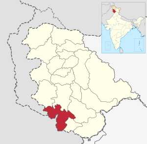
Jammu (district)
| Jammu District | |
|---|---|

|
|
| Union Territory | Jammu and Kashmir |
| Division : | Jammu |
| Administrative headquarters : | Jammu |
| Area : | 2342 km² |
| Residents : | 1,529,958 (2011) |
| Population density : | 653 inhabitants / km² |
| Website : | jammu.gov.in |
The Jammu District is a district in the Indian Union Territory of Jammu and Kashmir .
The district of Jammu extends over the Siwaliks to the lowlands. The Tawi River flows through the district and the district capital Jammu in a south-westerly direction.
The district has an area of 2342 km² and 1,529,958 inhabitants (2011 census). In 2001 the population was 1,357,077. The population density is 653 inhabitants per square kilometer.
The district is divided into 4 Tehsils : Akhnoor , Bishnah, Jammu and Ranbir Singh Pora.
Web links
Commons : Jammu District - Collection of images, videos and audio files
Individual evidence
Coordinates: 32 ° 43 ' N , 74 ° 52' E
