Kathua (District)
| Kathua District | |
|---|---|

|
|
| Union Territory | Jammu and Kashmir |
| Division : | Jammu |
| Administrative headquarters : | Kathua |
| Area : | 2651 km² |
| Residents : | 616,435 (2011) |
| Population density : | 233 inhabitants / km² |
| Website : | kathua.gov.in |
The Kathua District is a district in the Indian Union Territory of Jammu and Kashmir .
The seat of the district administration is the city of the same name Kathua .
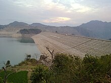
The district is located in the extreme southeast of Jammu and Kashmir. It extends from Pir Panjal over the Siwaliks to the lowlands. The Ravi River runs along the eastern district border and is dammed by the Ranjit Sagar Dam .
The district has an area of 2651 km² and 616,435 inhabitants (2011 census). In 2001 the population was 511,455. The population density is 233 inhabitants per square kilometer.
The district is divided into 5 Tehsils : Bani, Bashohli, Billawar, Hiranagar and Kathua.
Web links
Commons : Kathua District - Collection of images, videos and audio files
Individual evidence
Coordinates: 32 ° 25 ' N , 75 ° 32' E
