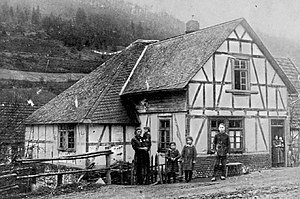
Cooking mill
| Cooking mill
|
||
|---|---|---|
|
Garsmühle around 1910 |
||
| Location and history | ||
|
|
||
| Coordinates | 51 ° 2 '54 " N , 8 ° 30' 33" E | |
| Location | Germany | |
| Built | 1608 | |
| Shut down | 1934 | |
| Status | Desolation | |
| technology | ||
| use | Flour mill , oil mill | |
| drive | Watermill | |
The Garsmühle was a residential area with a grinding and oil mill , as well as an agricultural area in the former municipality of Alertshausen , today's town of Bad Berleburg in the Siegen-Wittgenstein district in North Rhine-Westphalia . The mill belonged to the parish of Elsoff.
location
The mill was located below the Garsbach on the road 817 towards Elsoff . The system was mainly fed from the Elsoffbach .
history
The mill was built in 1608 as an overshot water mill . Initially, the property belonged to the municipality of Elsoff. In the years 1644/1645 the mill was not occupied due to the war. In 1712 the grinding mill was expanded to include an oil mill. From 1819 the mill belonged to the Elsoff district. In 1934 the property was completely destroyed by fire. At the end of the Second World War, a dispersed SS troop ambushed a US jeep at Garsmühle. One US soldier is killed and one wounded. The SS men take the wounded man to the cellar of the mill. Then they fled in a captured jeep across the Bohland to Berleburg. Remnants of the former settlement were still there until the mid-1990s.
literature
- Günther Wrede: Territorial history of the County of Wittgenstein , 1927.
- Wittgensteiner Heimatverein eV: sheets of the Wittgensteiner Heimatverein
- Lars Womelsdorf: Contributions to the history of the village Alertshausen

