Geography and Cartography in Medieval Islam


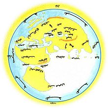
The Muslim geography and cartography based on the Greco-Roman geography and peaked by Al-Idrisi in the 12th century.
Beginning in the 8th century based on Hellenistic geography, Islamic geography was supported by the Abbasid caliphs of Baghdad . Various Islamic scholars contributed to the subsequent development, including Al-Chwarizmi and Abu Zaid al-Balchi (founders of the Balchi School ). Islamic cartographers took their mathematical and astronomical bases from Claudius Ptolemy 's Almagest .
In the 11th century, the scholar Mahmud al-Kāshgharī was the first to draw an ethnographic map of the Turkish peoples of Central Asia. Later, in the early modern developments, there were notable cartographers in the Ottoman Empire , including Piri Reis . Many Islamic scholars like Ibn Hazm , Ibn al-Jschauzī and Ibn Taimīya all had the idea that all heavenly bodies are round.
Long journeys were usually required to produce maps and geographic works. Every year Muslims from Africa , Al-Andalus , Persia and India came to the Arab city of Mecca .
literature
- Gerald R. Tibbetts: The Beginnings of a Cartographic Tradition , in: John Brian Harley, David Woodward: Cartography in the Traditional Islamic and South Asian Societies , Chicago 1992, pp. 90-107
- Alavi, SM Ziauddin: Arab geography in the ninth and tenth centuries , Aligarh : Aligarh University Press, 1965
- Edson and Savage-Smith: How the Muslims Made Geography , 2004
- Yossef Rapoport: Islamic Maps. The other view of the world. [›Islamic Maps‹, 2019] Translated from English by Jörg Fündling. Darmstadt: Wbg Edition 2020. ISBN 978-3-534-27205-1