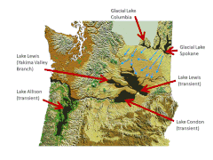
Glacial Lake Columbia

The Glacial Lake Columbia was that of an ice dam on the Columbia River reservoir formed; the ice dam came from the Okanogan lobe of the Cordilleran ice sheet when the flap during the Wisconsin glaciation a 1,300 square kilometers of Waterville Plateau west of Grand Coulee in the center of present-day US state of Washington covered. Lake Columbia was a significantly larger version of the modern reservoir behind the Grand Coulee Dam . The overflow of Lake Columbia - the divided Columbia River - first drained over the Foster Coulee and later, when the ice dam had grown, through the first Moses Coulee and finally over the Grand Coulee .
Glacial Lake Missoula
The Cordillera Ice Sheet also dammed the Clark Fork River and formed Glacial Lake Missoula , which flooded valleys in what is now western Montana behind a 2,000 ft (approx. 600 m) high ice dam . For more than 2,000 years, the ice dam broke again and again and with the Missoula floods released about 40 large volumes of water that used the drainage of the Columbia River and flowed through Glacial Lake Columbia. The first (and probably largest) flood involved a volume of water of about 2,500 cubic kilometers; smaller floods followed at intervals of around 20 ... 80 years. Since Glacial Lake Columbia was trapped behind the Okanogan Lobe (up to 1,300 ft (400 m) high), the lobe has effectively blocked the normal course of the Columbia River, damming the Missoula floods, and forcing the water over much of today's East Washington drain. Flood erosion created the Grand Coulee, Dry Falls , Palouse Falls, and the Channeled Scablands in what is now east Washington.
Deposits
The bottom of the Sanpoil arm of Glacial Lake Columbia shows several layers of deposits as well as different gradations and rhythmic repetitions in the deposit. Whenever Glacial Lake Columbia has been refilled between the Missoula Floods, the annual deposits ( varves ) between the Missoula Flood deposits can be seen; they help to prove the periodicity of these floods. The deposits from the floods can be distinguished from the varvae both by their strength and by materials that are foreign to the catchment area of the lake. Atwater reports 35… 55 varves between the flood deposits in Glacial Lake Columbia, suggesting a period of 35 to 55 years between dam breaks.
Individual evidence
- ↑ DESCRIPTION: Ice Sheets and Glaciations . USGS. Retrieved November 14, 2009.
- ^ A b c Brian F. Atwater: Periodic floods from glacial Lake Missoula into the Sanpoil arm of glacial Lake Columbia, northeastern Washington . In: The Geological Society of America (Ed.): Geology . 12, No. 8, 1984, pp. 464-467. bibcode : 1984Geo .... 12..464A . doi : 10.1130 / 0091-7613 (1984) 12 <464: PFFGLM> 2.0.CO; 2 .
- ^ Ingrid Hendy: A fresh perspective on the Cordilleran Ice Sheet . In: The Geological Society of America (Ed.): Geology . 37, 2009, pp. 464-467. bibcode : 2009Geo .... 37 ... 95H . doi : 10.1130 / focus012009.1 . Retrieved November 14, 2009.
