
Goethepark (Berlin)
| Goethe Park | ||
|---|---|---|
|
|
||

|
||
| Goethe monument | ||
| Basic data | ||
| place | Berlin | |
| District | Wedding | |
| Created | 1922-1924 | |
| Surrounding streets | Transvaalstrasse, Senegalstrasse, Seestrasse, Dohnagestell | |
| use | ||
| User groups | Leisure time , children, foot traffic | |
| Technical specifications | ||
| Parking area | 37 ha. | |
52 ° 32 '49.3 " N , 13 ° 20' 13.5" E
|
||

The Goethepark is a smaller park in the Berlin district of Wedding between Transvaalstrasse and Seestrasse .
Origin and location
The Goethepark was created as a recreation area in western Wedding in the phase of the expansion of residential and leisure opportunities following the urban industrial development of the district, which is predominantly populated by working-class families. It was created from 1922 to 1924 according to prior planning by the Berlin horticultural director Albert Brodersen Rudolf Germer , the horticultural director of the Wedding district. He developed part of the former Prussian manor district Plötzensee on the edge of the pine forest and swamp area Jungfernheide with its drifting sand dunes, which had passed into municipal ownership . The first completed park area corresponded to today's Goethepark without its functional areas on about 5 hectares. An initially envisaged expansion of the park in a northerly direction came about only after 1926, and then under new management and the designation as Volkspark Rehberge . Since the 19th century, the area of what would later become the Goethe Park had mainly served as a firing and training area for the Prussian artillery and cavalry.
For the entire area between the Transvaalstrasse, which was extended for this purpose in 1914, the African Strasse, the Dohnagestell and the Seestrasse , a contiguous Jungfernheide housing estate was initially planned. According to the development plan of 1919, however, only a smaller one and two-family house settlement was built on the eastern edge of the new park. It was the only such settlement in Wedding that was available to war invalids from the First World War and their survivors. To the south, the Goethepark separates a number of cemeteries of the first Weddingen suburban parishes, which were established in the 19th century, from Seestrasse as a former thoroughfare. To the north, across the Transvaalstrasse, it is joined by the large Rehberge public park, which was laid out a little later (1926 to 1929) and to which the district's green space management assigns it.
Topography and design
Since the Second World War, the rectangular area of the Goethepark , which is actually modeled on a landscape park, has encompassed around half of its original area. The other half is used by the district road and green space office, an extensive day-care center and the Dohnagestell meeting place , a youth and leisure home used by the Federal Association of Lebenshilfe in a listed half-timbered house. The halving of the park area into the landscape park and the area occupied by a nursery of the district administration already happened during the expansion of the Rehberge public park after 1926. The park design makes the terrain slightly jagged by dunes or later earthfills with the excavation of the Berlin-Spandau shipping canal take advantage of a loosely formalized structure. Some paths, up to about eight meters high, cross the central part of the park. They also form a ravine in its northern part. There are masonry rondells at three higher points of the connected network of paths. They are now overgrown by trees and undergrowth as visual markings. Two of them are located at related end points of a diagonal line of sight in the center of the park. An outside path surrounds the designed terrain and enables transitions into the Volkspark and into the streets of the two-family housing estate. The open landscape park in traditional British style corresponds to a larger lawn in the southern part of the Goethepark, which is framed as a gentle hollow by tall trees at its raised edges. Their leisure activities include a small children's playground and a number of benches set up along the edges. A stone memorial based on Johann Wolfgang von Goethe's death mask reminds of the eponymous poet at one point.
Name of the Goethepark
The naming of the Goethepark between its completion and the present was confusing for a long time. His name initially formed a counterpart to the Schillerpark , which was built before the First World War, on the other side of Müllerstraße as the suburban arterial road from Wedding to the north. In addition to the early planning of a larger facility than the Goethepark, which was completed by 1924, the fluctuating placement of the ancient dunes on both sides of this old military road (Rehberge or Wurzelberge) initially contradicted the use of the term Rehberge for the new Volkspark by its planner Erwin Barth . In Barth's sketch for the Rehberge park, neither the name Goethepark nor its area appears. There is a connection here with the controversial designs between the district and urban authorities of the green space management. At the same time, Barth's plan sketches were juxtaposed with several designs by the Wedding District Office and his district garden director Rudolf Germer. Of three Berlin city maps from 1930, one mentions the entire neighboring park area only as Volkspark Rehberge, another only as Goethepark, like the local population for a long time. In contrast to the city map from the same publisher in the same year, this also corresponded to the Pharus plan from 1930. It names the greater part of Barth's Volkspark as Goethepark and only uses the term Volkspark Rehberge for its western edge and the allotment garden colony Rehberge.
An overview map of North Berlin from 1937 shifts the two names of the parks in an initially planned, but mostly politically motivated way. It contains a subdivision of the north-western district that runs counter to the geographical conditions. It uses the name Goethepark for the entire area of Volkspark and Goethepark and relocates Volkspark Rehberge, as if it had only been planned, almost completely to the western adjacent area of the military area of today's Julius Leber barracks, which has been expanding since 1936 . There, the existing Prussian police barracks, contrary to international law, were converted into the General Göring air force barracks and, before 1939, into the Hermann Göring military barracks. This plant disappears from the map, as do all unpopular projects and names from the progressive past. A similar camouflage of the barracks area as an unnamed green area is adopted by a Berlin map from 1947 after the formation of the French sector in Berlin. A residual terminological uncertainty continues into the later designation of the Goethepark by the Senate Department for Urban Development and the Environment . It limits the Rehberge Park to an area that excludes the Goethepark, but explains it as part of it in the same text.

Large lawn

Access on the west side

playground
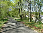
Hochweg on Senegalstrasse

Johann Wolfgang von Goethe by Paula Hansel-Pauly, 1957


_Johann_Wolfgang_von_Goethe%26Paula_Hansel-Pauly%261957.jpg)
Another “Goethepark” in Charlottenburg
There is also a small complex of the same name near Wilmersdorfer Straße in the Berlin district of Charlottenburg , but it does not have a typical park character.
literature
- Heidrun Joop: Berlin streets. Example: Wedding . Edition Hentrich, Berlin 1987, ISBN 3-926175-35-4 .
- Gerhild HM Komander : Wedding: on the way from red to colored . Berlin Story Verlag, Berlin 2006, ISBN 3-929829-38-X , p. 161-164 .
- District Office Wedding of Berlin (ed.): Wedding is green . Verlagsbuchhandlung Koll, Berlin 1985, ISBN 3-925024-03-4 , p. 32-34 .
- District office Wedding of Berlin (ed.): Berlin and Wedding in maps, plans and pictures . FAB Verlag, Berlin 1990, ISBN 3-927551-20-1 , p. 33-35 .
- TU Berlin (ed.): The future of metropolises: Paris-London-New York-Berlin . 3 volumes. TU, Berlin 1984, ISBN 3-496-00805-9 , pp. I, pp. 469-471; II, pp. 72-79; III, pp. 115-118 .
- Ralf Schmiedecke (ed.): Forays through Berlin-Wedding . Sutton, Erfurt 2008, ISBN 978-3-86680-419-7 .
- District Office Wedding of Berlin (ed.): Volkspark Rehberge and the expansion of the adjacent open spaces . [June 1927]. Archiv Verlag, Braunschweig 1992.
- Karin Mahlich: The Rehberge Park . In: Helmut Engel u. a. (Ed.): Berlin history landscape. Places and events . tape 3 : Wedding. Nicolai, Berlin 1990, ISBN 3-87584-296-0 , pp. 446-464 .
Web links
- Goethepark toboggan run
- Weddingweiser Volkspark Rehberge and Goethepark
- Entry in the Berlin State Monument List
Individual evidence
- ↑ Pharus Plan Berlin 1912
- ↑ JF Schneider, plan of Berlin and the surrounding areas in 1802
- ^ Pharus Large Edition Berlin 1928, dating 1930
- ↑ Pharus Plan Berlin 1929
- ↑ Silva overview plan of the North Berlin suburbs . Publishing house for local culture Willy Holz, Berlin 1937.
- ↑ Schropp's Großer Berliner Verkehrsplan 1947. ( Page no longer available , search in web archives ) Info: The link was automatically marked as defective. Please check the link according to the instructions and then remove this notice. alt-berlin.info
- ^ Volkspark Rehberge. Senate Department for Urban Development and the Environment
- ↑ Goethepark / Kaiser-Friedrich-Straße on berlin.de, accessed on June 21, 2016