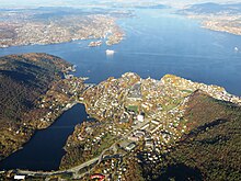
Gravdal (mountains)
Gravdal is a district in the Laksevåg district of the Norwegian city of Bergen in the province of Vestland .
geography
It is located on Gravdalsbukten bay on the south coast of the Byfjord , about three kilometers west of downtown Bergen. Nygård borders directly to the east . The Lyderhorn mountain rises to the west . Lake Gravdalsvatnet is south of the village , and Riksvei 555 runs there .
Gravdal covers an area of 2.25 km² and has 1215 inhabitants (as of 2014).
history
Gravdal is already mentioned in the Nordic saga. There was a farm here that belonged to the Munkeliv monastery before the Reformation . In 1649 he fell to the crown. A mill had existed since the 13th century and was in operation until 1899. Folkvard Riisbrich is known to have been the first private owner, whose family still owned the property until 1802. In the second half of the 18th century, Lieutenant Colonel Philip Nicoll owned Gravdals, who turned it into a place of entertainment. It is believed that the core of the Kommandantboligen building, which still exists today, goes back to him.
A later owner was the MP August Konow . He ran a tannery from 1812 to 1848 . Johan Ingebrechtsen is known as a subsequent owner. In 1897/99 Gravdal came into the possession of the Ministry of Defense. The old main house became a residence, the mill building was converted into a barracks.
In later times the old tannery was converted into a garden center and other areas were converted into residential use. Gravdal is the seat of the Sjøkrigsskolen Naval Academy . There is a port area by the Byfjord.
There are several archaeological sites in the Gravdal area. Fragments of millstones from Selbu and Germany , presumably from Mayen, were found in the harbor on the Byfjord . Late medieval settlement remains were found in Gravdalsvatnet in the immediate vicinity of the shore. On the banks of the Gravdalsvatnet there is an anchor from the 17th century, which was found in the 1950s / 1960s by shrimp trawling in the North Sea , probably in the area of the Flategrunnen . In the center of the village is the listed Gravdal hovedgård garden . North-east on the edge of Gravdalsbukten bay is Wallemsviken bay , where ammunition and explosives magazines for the Norwegian Navy were built in the 1890s. The preserved buildings are also under monument protection.
Personalities
The Norwegian rival king Sigurd Sigurdsson Markusfostre was beheaded in Gravdal in 1163, just under ten years old.
Web links
Individual evidence
- ↑ Gravdalsviken in kulturminnesok.no (Norwegian)
- ↑ Gravdalsvannet / Undervannsstemme - demning in kulturminnesok.no (Norwegian)
- ↑ Deponering Gravdalsvatnet in kulturminnesok.no (Norwegian)
- ↑ Gravdal hovedgård in kulturminnesok.no (Norwegian)
- ↑ Wallemsviken in kulturminnesok.no (Norwegian)
Coordinates: 60 ° 23 ' N , 5 ° 14' E

