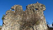
Great Abkhazian Wall
The Great Abkhazian Wall ( Georgian აფხაზეთის დიდი კედელი ) also Kelassurier Wall ( Georgian კელასურის კედელი ) is the largest medieval fortification and a cultural monument in Georgia . The plant is located in Abkhazia and protected the western Georgian coastal region.
description
The ruins of the fortification extend over a length of 160 kilometers. A complete mapping of the complex is still pending, so far 279 defense towers and structures on the wall and in the hinterland (signal towers) have been identified.
The wall begins near Sukhumi , at the mouth of Kelasuri , a few steps from the shores of the Black Sea . It initially runs parallel to this river in a north-easterly direction for about 20 kilometers to the foot of the Caucasus Mountains . From there it runs parallel to the mountains and cuts around 15 river valleys, making skilful use of topographical conditions. At the edge of the Engurital it turns to the southwest in order to run back towards the Black Sea coast.
The course can still be followed in numerous places in the area, but larger passages have already been destroyed by the forces of nature or the disinterest of the residents.
The wall was only one to two meters thick and apparently had no battlements for long stretches.
The towers have a uniform typology, they have a rectangular floor plan with a base area of around 7 × 8 m to 8 × 9 m and a total height of only 4 to 6 m. The towers could once only be entered via ladders to the high entrances. In the upper floors there were loopholes on all sides, from which it was concluded that the structures were defended with firearms. The distance between the towers was relatively small - it is 40 to 120 m - always depending on the topography of the terrain.
exploration
The complex is still a mystery, archaeological research is currently hampered by the conflict around Abkhazia, and the building is being used as evidence of a heroic past by nationalist circles on both sides.
According to some historians, it is a Byzantine border fortification - comparable to the Anastasius Wall north of Constantinople or older fortifications on the edge of the Eastern Roman Empire . However, the poor quality of the walls, the low height and thickness of the walls and the inadequate foundation of the towers cast doubt on this view. According to another opinion - which is proven by building archaeological research by the Soviet (Abkhazian) archaeologist Juri Voronow , the entire complex was not built until the 17th century. It therefore served to secure the principality of Mingrelia , ruled by Lewan II. Dadiani (1611-1657) , that, through constant attacks from the hinterland (Turks, Caucasians) on the one hand, and in the war with a rival neighboring principality on the other, in the period from 1628 to 1653 was forced to build this defense-technically obsolete facility. A key witness can be referred to the report of an Italian missionary Arcangelo Lamberti , he traveled to the Caucasus and mentions in his travel description that the wall was conceived by Megrel princes and served to ward off their enemies. The report also informs about a determination by the prince, which forced all subjects, even clergymen, to one month of forced labor building the wall and digging.
Web links
Individual evidence
- ^ List of Georgian Monuments. Georgian Web, 2011, Retrieved May 1, 2011 (Georgian).
- ↑ Michail Ivaschenko: Overview map. 2011, accessed on May 1, 2011 (Russian, overview map showing the course of the border fortifications known around 1990).
Coordinates: 42 ° 57 '59.6 " N , 41 ° 4' 8.9" E


