Guajará-Mirim
| Guajará-Mirim | ||
|---|---|---|
|
Coordinates: 10 ° 47 ′ S , 65 ° 20 ′ W Guajará-Mirim on the map of Rondônia
|
||
| Basic data | ||
| Country | Brazil | |
| State | Rondônia | |
| Residents | 47,048 | |
| City insignia | ||
| Detailed data | ||
| surface | 24,855.724 km 2 | |
| Population density | 2 people / km 2 | |
| height | 128 m | |
| Waters | Río Mamoré | |
| City Presidency | Rodrigo Melo Nogueira | |
| Website | ||
Guajará-Mirim , officially Município de Guajará-Mirim , is a municipality in the state of Rondônia , in northwestern Brazil . To the west, Guajará-Mirim borders the city of Guayaramerín in Bolivia ; the two cities are separated by the Río Mamoré . The municipality of Guajará-Mirim has 41,656 inhabitants (as of 2010) and is 24,855.724 km² in size.
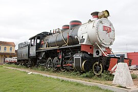
Thousands of workers died during the construction of the "Estrada de Ferro Madeira-Marmoré" ( Madeira-Mamoré Railway ). It is therefore known as the "death railway" and ran until 1972 on the 364-kilometer route from the Madeira River to the town of Guajará-Mirim on the Río Mamoré .
Diocese of Guajará-Mirim
Web links
Commons : Guajará-Mirim - collection of images, videos and audio files
Individual evidence
- ↑ IBGE : Guajará-Mirim. Retrieved October 16, 2017 .
- ↑ "Porto Velho: In the footsteps of the» Death Railway «in Brazil"


