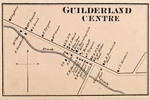
Guilderland Center
| Guilderland Center | ||
|---|---|---|
|
Location in New York
|
||
| Basic data | ||
| Foundation : | 1790s | |
| State : | United States | |
| State : | new York | |
| County : | Albany County | |
| Coordinates : | 42 ° 42 ′ N , 73 ° 58 ′ W | |
| Time zone : | Eastern ( UTC − 5 / −4 ) | |
| Postal code : | 12085 | |
| Area code : | +1 518 | |
| FIPS : | 36-31115 | |
| GNIS ID : | 951904 | |
Guilderland Center is a hamlet in the Town of Guilderland in Albany County , New York . The village is on New York State Route 146 and on Black Creek , a tributary of the Norman Kill .
history
Guilderland Center includes the factories built by Peter Broeck at French's Mills around 1795. This name (sometimes referred to as French's Hollow) is derived from Abel French, who founded his own mill around 1800. French's Hollow and mills were largely destroyed when Black Creek was dammed into Watervliet Reservoir in 1916. Abel French's mill would be torn down and this was where the pump house was built. Guilderland Center was originally called Bangall by the locals, a nod to the town's bad reputation for brandy, horse racing, and raw manners. Around 1803, when the Town of Guilderland was separated from the Town of Watervliet , the current name Guilderland Center came into fashion due to its central location, and the post office was also given this name after its establishment. In 1866, Guilderland Center had 450 residents. District Number 6 Cobblestone School , built in 1860, was built here and, although not in use since 1941, is still owned by the Guilderland Central School District .
geography
For a hamlet like Guilderland Center, the exact boundaries are not set, but generally speaking, the village extended along New York State Route 146 west from Van Buren Boulevard to Hurst Road and includes adjacent areas along School Road (Albany County Route 201) and Depot Road (Albany County Route 202) to their intersection and Hurst Road and French Mill Road. Guilderland Center is south of Watervliet Reservoir on Black Creek.
| Watervliet Reservoir | ||
| Village of Altamont |

|
Guilderland |
| Town of New Scotland Village of Voorheesville |
Buildings
- Helderberg Reformed Dutch Church - on the National Register of Historic Places
- St. Mark's Lutheran Church - on the National Register of Historic Places
- Frederick Crouse House - on the National Register of Historic Places
supporting documents
- ^ A b George Howell and Jonathan Tenney: Bi-Centennial History of Albany: History of the County of Albany from 1609-1886 . WW Munsell and Company, 1886, pp. 852-55 (accessed February 10, 2010).
- ↑ a b Alice Begley and Mary Ellen Johnson: Guilderland, New York . Ed .: Arcadia Publishing. 1999, ISBN 0-7385-0112-3 , pp. 74-84 ( google.com ).

