
Gurlitt Island
| Gurlitt Island | ||
|---|---|---|
| Waters | Outer Alster | |
| Geographical location | 53 ° 33 '33.4 " N , 10 ° 0' 28.8" E | |
|
||
| length | 120 m | |
| width | 60 m | |

The Gurlitt island is a 120 meter long island near the eastern shore of Hamburger Außenalster , from which it is separated by a narrowest in its place three meters wide water arm. The island is 120 by 60 meters, and there are jetties with a length of another 120 meters. The Gurlitt Island is accessible to pedestrians via a steel bridge. Before the Second World War, a suspension bridge stood here, the steel cables of which were held in place by stone dragon heads. These are now in Hammer Park and serve as gargoyles there .
The rowing club Allemannia from 1866 , the Hamburg sailing club and the Käpt'n Prüsse sailing school are located on the island, surrounded by lush willow vegetation . In summer the island is a popular meeting place for locals and tourists. In the 1940s, Gurlitt Island was an insider tip among the swing youth of that time .
The place got its name after the nearby Gurlittstraße. This in turn is named after the philologist Johann Gottfried Gurlitt (1754–1827).

The Gurlitt Island with the clubhouse of the rowing club Allemannia from 1866
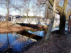
Bridge to Gurlitt Island

Dragon heads of the old bridge, now in Hammer Park

Rocks on Gurlitt Island
.jpg)
.jpg)

