Gympie region
| Gympie region | |
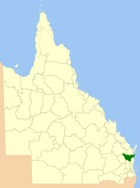
 Location of the Gympie region in Queensland |
|
| structure | |
| State : |
|
| State : |
|
| Administrative headquarters: | Gympie |
| Dates and numbers | |
| Area : | 6,884.0 km² |
| Residents : | 49,559 (2016) |
| Population density : | 7.2 inhabitants per km² |
Coordinates: 26 ° 11 ′ S , 152 ° 39 ′ E The Gympie Region is a local government area (LGA) in the Australian state of Queensland . The area is 6884 km² and has about 49,500 inhabitants.
geography
The region is located in the southeast of the state on the coast about 150 km north of the capital Brisbane .
The largest city and administrative seat of the LGA is Gympie with around 18,000 inhabitants. The region includes the following districts and towns: Amamoor, Amamoor Creek, Anderleigh, Araluen, Banks Pocket, Barambah, Beenaam Valley, Bella Creek, Bells Bridge, Black Snake, Bollier, Boonara, Booubyjan, Brooloo, Calico Creek, Canina, Carters Ridge, Cedar Pocket, Chatsworth, Cinnabar, Coles Creek, Cooloola, Cooloola Cove, Coondoo, Corella, Crownthorpe, Curra, Dagun, Downsfield, East Deep Creek, Elgin Vale, Fishermans Pocket, Gilldora, Glanmire, Glastonbury, Glen Echo, Glenwood, Goomboorian, Goomeri, Goomeribong, Greens Creek, Gunalda, Gympie, Imbil, Inskip, Johnstown, Jones Hill, Kandanga, Kandanga Creek, Kanigan, Kia Ora, Kilkivan, Kinbombi, Kybong, Lagoon Pocket, Lake Borumba, Langshaw, Long Flat, Lower Wonga, Manumbar, Manyung, Marys Creek, Mcintosh Creek, Melawondi, Miva, Monkland, Mooloo, Mothar Mountain, Moy Pocket, Mudlo, Munna Creek, Nahrunda, Neerdie, Neusa Vale, North Deep Creek, Oakview, Pie Creek, Rainbow Beach, Ross Creek , Scotchy Pocket, Scrubby Creek, Sexton, South side, Tamaree, Tandur, Tansey, The Dawn, The Palms, Theebine, Tin Can Bay, Toolara Forest, Traveston, Tuchekoi, Two Mile, Upper Glastonbury, Upper Kandanga, Veteran, Victory Heights, Wallu, Widgee, Widgee Crossing North, Widgee Crossing South, Wilsons Pocket, Windera, Wolvi, Woolooga, Woondum and Wrattens Forest.
history
Today's Gympie region was created in 2008 from Cooloola and the Kilkivan Shire and the southern third of the Tiaro Shire. The Cooloola Shire consisted of the City of Gympie and the Widgee Shire until 1993.
administration
The Gympie Regional Council has nine members. The mayor (mayor) and eight other councilors are elected by all residents of the region. The LGA is not divided into electoral districts.
Web links
- Official site of the Gympie Regional Council (English)
- Queensland Places: Gympie Regional Council (English)
Individual evidence
- ↑ a b Australian Bureau of Statistics : Gympie (R) ( English ) In: 2016 Census QuickStats . June 27, 2017. Retrieved May 14, 2020.
- ↑ Australian Bureau of Statistics : Gympie ( English ) In: 2016 Census QuickStats . June 27, 2017. Retrieved May 14, 2020.