Höchst cemetery
The Höchst Cemetery is one of the 37 municipal cemeteries in Frankfurt am Main . It is located in the suburb of Unterliederbach and is one of the six electoral cemeteries in the city. The cemetery, opened in 1924 as the Höchst Main Cemetery, has an area of 16.8 hectares.
History of the Supreme Cemeteries
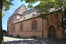
The churchyard at the Justinuskirche
The original cemetery of the town of Höchst has been the place around the Justinuskirche since the Middle Ages . In particular, General Preceptors and Canons of the Antonite Order , to whose monastery the church belonged , were buried in the Justinuskirche . The von Dalberg and von Kapp families had family tombs in the Justinuskirche.
After the ossuary at Justinuskirche had been demolished in 1804, the churchyard was abandoned in 1810. It was demolished between 1930 and 1932 as part of the renovation of the church and the square in front of the church was paved. Only a Pietà on the north facade of the church, eight tombstones inside the church and a few weathered tombstones in the garden on the Main side remind of the burial place.
The Luciuskirchhof
In 1810, the city of Höchst set up a new cemetery west of the Untertor on the road to Mainz in the area of today's Luciusstrasse. With the rapid growth of the city after 1870, the Luciuskirchhof was soon back within the built-up area and was abandoned in 1885 in favor of a new facility in the then undeveloped Höchst Oberfeld on the road to Sossenheim - today's Kurmainzer Strasse. The cemetery complex was leveled in 1926 and transformed into Lucius Park. In 1975/1976 the city had the Paul Ehrlich vocational school built on the site. Part of the park became a school playground. All that remains of the former cemetery is the surrounding wall.
The old highest cemetery
The old Höchst cemetery ( 50 ° 6 ′ 35 ″ N , 8 ° 33 ′ 7 ″ E ) is now in the Sossenheim district and is officially known as the cemetery on Kurmainzer Strasse . The cemetery was opened in 1885. The 2.37 hectare facility served as the sole cemetery for Höchst until the opening of the new Höchst main cemetery in 1924. It is still used for burials of deceased Höchst residents. Many old tombs from the 19th century and a war memorial for those who died in the Franco-Prussian War have been preserved .
The highest main cemetery
The villages of Unterliederbach , Zeilsheim and Sindlingen were incorporated into Höchst in 1917. After the old cemeteries of the core city of Höchst and its districts were occupied in the early 1920s, the city decided to build a new central cemetery on Sossenheimer Chaussee . City architect Paul Wempe was entrusted with the planning of the facility . Wempe designed the cemetery with an area of 13 hectares and an extension of 430 by 615 meters. He also designed the mourning hall of the cemetery. Wempe's colleague, the surveyor Carl Rohleder, had Windthorststraße laid out at the same time in his development plans for the Höchst Oberfeld, which runs straight to the cemetery portal and continues along its main axis to the center of the cemetery.
Graves of well-known personalities in the highest cemeteries
- Chlodwig Poth , satirist, draftsman, caricaturist and comic artist, Höchst cemetery
- Günter Sare , Höchst cemetery
- Hermann Schmitt-Vockenhausen , Höchst cemetery
- Friedrich Stolz , Höchst Cemetery
literature
- Wolfgang Metternich: The urban development of Höchst am Main. Frankfurt-Höchst 1990: City of Frankfurt and Association for History and Archeology.
- Rudolf Schäfer: Burials in the Justinuskirche in Höchst am Main. Höchst history books 13. Frankfurt-Höchst 1968: Association for history a. Antiquity.
- Rudolf Schäfer: The Church of St. Justinus at Höchst am Main. Höchst history books 18/19. Frankfurt-Höchst 1973: Association for history a. Antiquity.
- Rudolf Schäfer: Chronicle of Höchst am Main. Frankfurt am Main 1986: Waldemar Kramer.
- Paul Wempe: Building activity in the city of Höchst in the post-war years. Settlements and housing construction In: Magistrat der Stadt Höchst am Main (ed.): Höchst am Main. Highest a. M. 1925: Publishing house of the city administration. Pp. 31-42.
- Department for Environment, Energy and Fire Protection (Ed.) Frankfurter Friedhöfe. Preserve green spaces. Protect nature. Frankfurt am Main 1993: City administration. frankfurt.de, accessed on Feb. 25, 2020
Web links
- Höchst Friedhof at par.frankfurt.de , the former website of the City of Frankfurt am Main
- Old Höchst Friedhof at par.frankfurt.de , the former website of the city of Frankfurt am Main
Coordinates: 50 ° 6 ′ 55 ″ N , 8 ° 32 ′ 54 ″ E


