Highest palace square
| Highest palace square | |
|---|---|
| Place in Frankfurt am Main | |
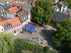
 View from the castle tower to the highest castle square |
|
| Basic data | |
| place | Frankfurt am Main |
| District | Maximum |
| Created | Middle of the 13th century |
| Confluent streets | Castle moat, Justinusplatz |
| Buildings |
Highest castle , house "Der Karpfen", customs tower, restaurants "Zum Schwan", "Zum Bären" and "Alte Zollwache" |
The Höchst Schloßplatz is a historic square in the Höchst old town . It is located between Bolongarostrasse in the north, Höchst Castle in the west, Justinuskirche in the east and the old city fortifications with customs tower and main gate in the south. The square is around 1,100 m 2 .
Many Frankfurters consider the Höchster Schloßplatz to be one of the most beautiful squares in the city because of its historical buildings. Because of its three traditional restaurants "Alte Zollwache", "Zum Bären" and "Zum Schwan", it is a popular excursion destination from spring to autumn.
history
With the construction of the Höchster Zollburg , the forerunner of the Höchst Castle, and the excavation of the surrounding moat, the Schloßplatz was largely raised to its current level in the middle of the 13th century. In the following hundred years, the rows of houses on the north and east sides of the square were built. The customs tower on the south side of the square was built in the middle of the 14th century.
However, the free space of the square did not have the current dimensions, since on the west side considerable areas were taken up by the area of the castle and by an arm of the Liederbach flowing here at that time . With the city elevation in 1355 and the granting of market rights to the young city a year later, the Schlossplatz temporarily became the first Höchst market square.
The oak that now shadows the southern part of the castle square was planted in March 1872 by the Höchst Schützengemeinschaft in memory of the Franco-German War as a "peace oak ". In September 1910 the Brüningbrunnen was built on the Schloßplatz. It was to serve as a memory of Adolf von Brüning , the co-founder of Hoechst AG , and his wife Clara. The fountain was relocated to the northeast side of the Höchst Market in the summer of 1938 .
In 1908, the von Brüning family bought the Höchst Castle from the financial authorities, who owned it. This also included the castle square and the customs tower with the customs garden. The new owners transferred the customs tower and the castle square to the city of Höchst, with the condition that the castle would be preserved.
The Schloßplatz received its present appearance in 1977. It was provided with a "historical" cobblestone pavement. The fountain in the square today was built on the site of an earlier fountain that was covered under the original paving.
Important buildings
The development of the castle square dates from the 16th to the 18th century. Some of the original buildings were destroyed in the city fire of 1586 and in the Thirty Years' War and later rebuilt.
Important buildings are:
- the Höchst Castle with its Renaissance gate and Gothic tower with a baroque dome;
- the customs tower on the south side of the square originally dates from the 14th century, it was rebuilt in 1664 after being destroyed in the Thirty Years' War;
- the house "Der Karpfen" on the west side of the castle square next to the customs tower was already a well-known inn around 1500, it was rebuilt in 1633 after being destroyed in the war, in 1973 it was demolished due to dilapidation and rebuilt in its old structure;
- the inn “Zum Bären” on the north side of the Schloßplatz with its facade in the classical style dates from the year 1799, but already in the early 18th century a tavern “Schwarzer Bär” is reported here.
swell
- ↑ Stadtvermessungsamt Frankfurt am Main (ed.): Portal GeoInfo Frankfurt , city map
literature
- Manfred Gerner: half-timbered houses in Höchst am Main. Frankfurt-Höchst 1976: Association for history and antiquity eV
- Wolfgang Metternich: The urban development of Höchst am Main. Frankfurt-Höchst 1990: City of Frankfurt and Association for History and Archeology.
- Jutta Ochs: Squares in Frankfurt: A palace square with charm and without a concept. In: Frankfurter Rundschau of September 9, 2008. ( online )
- Rudolf Schäfer: Chronicle of Höchst am Main. Frankfurt am Main 1986: Waldemar Kramer.
Web link
Coordinates: 50 ° 5 ′ 55 ″ N , 8 ° 32 ′ 52 ″ E


