Huettenbach (Altmuehl)
| Huettenbach | ||
|
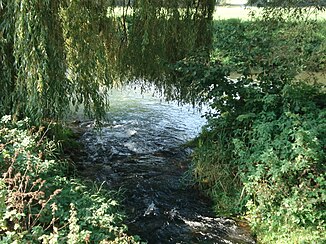
left arm of the Hüttenbach in Obereichstätt |
||
| Data | ||
| location | Bavaria (Germany) | |
| River system | Danube | |
| Drain over | Altmühl → Danube → Black Sea | |
| source | in the former quarry in Obereichstätt 48 ° 53 ′ 37 ″ N , 11 ° 8 ′ 8 ″ E |
|
| Source height | approx. 510 m | |
| Spring discharge |
MHQ |
750 l / s |
| muzzle | in the Altmühl coordinates: 48 ° 53 ′ 30 ″ N , 11 ° 8 ′ 0 ″ E 48 ° 53 ′ 30 ″ N , 11 ° 8 ′ 0 ″ E
|
|
| length | 255 m | |
|
The Hüttenbach flows into the Altmühl |
||
The Hüttenbach is a 255 m long, left tributary of the Altmühl , which flows along its entire length through Obereichstätt .
geography
Hüttenbachquelle
The source of the Hüttenbach lies on the northern edge of the former Obereichstätter quarry. It is a strong karst spring (geotope no. 176Q007) that can pour up to 750 liters per second. Today it is privately owned.
course
The Hüttenbach flows in two arms through Obereichstätt . Part of its crystal clear spring water is fed into a water treading facility. Past the houses of the old ironworks, the Hüttenbach flows into the Altmühl .
The street Am Hüttenbach in Obereichstätt was named after him.
history
The abundant source of the Hüttenbach is probably the reason for the emergence of Obereichstätt and a prerequisite for the construction of the iron and steel works . Around 1700 Hüttenbach operated three mills, the upper, lower and powder mills (later called the oil mill), as well as the so-called Pochhammer , in which the iron was forged.


