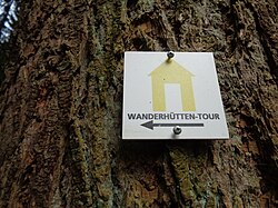
Hut hiking trail
| Hut hiking trail | |
|---|---|
 Waymarking |
|
| Data | |
| length | 12 km |
| location | Saar-Palatinate District |
| Start / finish point | Oberwürzbachhalle car park in Oberwürzbach 49 ° 14 ′ 36 ″ N , 7 ° 8 ′ 42 ″ E |
| Type | Circular hiking trail |
| Level of difficulty | medium |
| season | all year round |
The hut hiking trail is a premium hiking trail in Saarland . On his way he connects three huts and a farm with catering. The 2.5 km longer Kahlenberg loop leads to another hut, the Kahlenberghütte of the Pfälzerwaldverein Rohrbach.
description
The hiking trail begins at the Oberwürzbachhalle parking lot. Going north, it crosses the Würzbach and reaches a forest path above the cemetery, which leads into the Laichweihertal. Here he reaches the historic wash well from 1927, which is located at the beginning of the Laichweih valley. Now the route turns north and after a kilometer it reaches the club hut of the Oberwürzbach fishing club . The path now meanders up to the Eichertsfels , a natural monument of the red sandstone . At the next crossroads the path leads to the right and soon crosses a wide path. The path then leads steeply downhill to the Schopphübelhütte of the Hassel hiking club . The path now leads a bit downhill and reaches the outskirts of Hassel. Here the path leads to the left into a meadow valley past the village of Hassel. In the valley, the path branches into the 2.5 km longer Kahlenberg loop and the alternative path along the valley up to the hiking car park at the motorway entrance. From there it goes uphill on the left. After a beautiful view of Hassel, the path leads along an old quarry and on narrow paths to the Christkönigs- and Horstenbrunnen.
On the way back, the path climbs further and leads past the hornbeam fountain to Hof Hochscheid. A beer garden is cultivated there in the summer months. Then the path leads right along the edge of the forest and at the next crossroads leads down into the forest to the Weidenberghütte, a refuge in the forest. There it goes steeply downhill past a historical boundary stone, which represents the former border of the Grafschaft von der Leyen and the Wadgassen monastery . Then, after a steep descent, you come to a wide forest path. Following this to the left, the path reaches the fountain in Saulager and the Rotsolig fountain near the first houses in Oberwürzbach. Following the Reichenbrunner Straße for about 100 meters, the path leads down to the left into a valley and, following a crossroads, reaches the Martin-Sprengard-Brunnen, which is dedicated to a former pastor from Oberwürzbach, and a little later the Lourdes grotto. The path continues uphill a little and reaches a wide forest path that leads downhill to the hut of the Frohsinn hiking club. From here the path leads uphill to the left and after half a kilometer you reach Friedhofstraße, from which you return via the Würzbach to the starting point of the hike, the parking lot at the Oberwürzbachhalle.
Attractions
- historical wash well house in Oberwürzbach
- Laichweihertal nature reserve
- Eichertsfels
- Weidenberghütte lookout point
- Lourdes grotto in Oberwürzbach
- five fountains on the hiking trail
Web links
Individual evidence
- ↑ Premium hiking trail "Hüttenwanderweg" on the Saarpfalz-Touristik website
- ↑ "Waschbrunnenhaus". Retrieved November 10, 2019 . on the Oberwürzbach website
- ^ "Hof Hochscheid" on the website of Hof Hochscheid
- ↑ "Grenzsteine" on the Oberwürzbach website


