
Akrotiri port
| Akrotiri port | |||
|---|---|---|---|
| Data | |||
| UN / LOCODE | CY ACT | ||
| operator | Akrotiri Port Authority | ||
| Port type | Protective harbor | ||
| Total area of the port | 5 hectares | ||
| website | Akrotiri Port Authority | ||
| Geographic information | |||
| place | Akrotiri | ||
| republic | Republic of Cyprus | ||
| Country | Republic of Cyprus | ||
 |
|||
| Coordinates | 34 ° 34 '17 " N , 33 ° 1' 58" E | ||
|
|||

The port of Akrotiri ( Greek Λιμάνι Ακτορίνης ) is a protective port on the Akrotiri peninsula in Cyprus .
geography
The port facility is located almost five kilometers east of Akrotiri in the British overseas territory of Akrotiri and Dekelia in Akrotiri Bay on the Mediterranean . The Limassol Salt Lake is five kilometers north and the port of Limassol is eight kilometers north . There is a second port basin for fishing two kilometers southwest of Akrotiri in Episkopi Bay . ⊙
history
The port was created in the 1960s as a dock for customs and patrol boats . After the military invasion of Cyprus by Turkey in 1974, Operation Atilla , its military importance increased and it was rapidly expanded. In the late 1970s, a 235 m long breakwater was placed in front of the port , so that normally only slight waves and tidal range have to be expected in the port basin . The landing stages were fortified with further quay walls and in the 1980s a floodlight system, ammunition store, a 15 m wide slipway and two helipads were added .
The ro-ro ramp , which was built in 1977, was expanded again in the 1990s and became an important location for the Royal Navy from 2003 when Great Britain entered the Iraq war . Since 2008/10 the presence of the Royal Navy has decreased significantly and some of the military facilities have been dismantled. Since then, recreational boating has sporadically found its way there at five berths .
Description and infrastructure
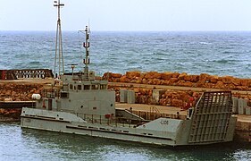
The port facilities cover a total area of around 5 hectares , one hectare of which is water. Wharf 1 is 25 m long and is used for small vehicles . Quay 2 has a RoRo ramp 20 m wide and can accommodate ships up to 50 m in length. In addition, there are 120 m of sloping bank at the breakwater in the harbor basin. Larger ships tie up at the outer pier , for which there is another RoRo ramp with a width of 10 m. In the port area, there are well-equipped sanitary, supply and disposal facilities as well as outdoor storage and almost 1000 m² indoor storage space. There is no regular cargo handling. There are no publicly accessible leisure activities, shopping or gastronomic offers, as well as a public transport connection.
The Aktorinis fishing port to the west of the peninsula occupies an area of 0.5 hectares, of which about 1000 m² is the port basin. The L-shaped breakwater there has a length of 110 m. The quay lengths are 20 + 10 + 5 m and there is a 20 m² farm building.
Both ports are unsuitable for tourist use and the Red Arrows use the area for their training flights.
Quay 2 (2006)

Panoramic view from quay 2 to the north (2010)

RoRo ramp at the pier (1977)

RFA Sir Geraint (L3027) Akrotiri Mole (1977)


,_Akrotiri_Mole_1977.jpg)
Web links
- Raft regatta and "Bird Man Competition" at the open day in 1991 in the port of Akrotiri (YouTube video 08:06 ")