Hala lake
| Hala lake | ||
|---|---|---|

|
||
| The Hala Lake in Qilian Shan | ||
| Geographical location |
|
|
| Drain | (no) | |
| Data | ||
| Coordinates | 38 ° 18 ' N , 97 ° 36' E | |
|
|
||
| Altitude above sea level | 4078 m | |
| surface | 596 km² (2006) | |
| length | 35 km | |
| Maximum depth | 65 m (2010) | |
| PH value | 9.3-9.6 | |
| Catchment area | 4690 km² | |
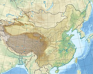
The Hala Lake ( 哈拉湖 , Ha lā hú ) is a lake in the Qilian Shan -Gebirge, on the northeast edge of Qinghai-Tibet Plateau in China .
The lake has a water surface of 590 km 2 . In the edge areas it is relatively flat and in its center it reaches a depth of 65 m. Its catchment area is a 4690 km 2 , drainless basin, crossed by a tectonic rift and surrounded by high mountain ranges. The highest of these mountain ranges is the Shule Nanshan in the north, whose summit is 5800 m above sea level. M. exceeds. The water level of the lake is 4078 m above sea level. M. is so deeply embedded between the mountains that it would have to rise by about 200 m for the water to flow out of the pool. Then the lake would head in a south-easterly direction towards Qinghai Lake, 100 km awayflow away. Although it has no drain, its salinity is only 1.8% maximum.
Individual evidence
- ↑ a b c d e f Wünnemann, Bernd, et al. "Implications of diverse sedimentation patterns in Hala Lake, Qinghai Province, China for reconstructing Late Quaternary climate." Journal of Paleolimnology 48.4 (2012): 725-749. ( PDF )
- ↑ a b Wan, Wei, et al. "Monitoring lake changes of Qinghai-Tibetan Plateau over the past 30 years using satellite remote sensing data." Chinese science bulletin 59.10 (2014): 1021-1035. ( HTML )
- ↑ a b Scheffers, Anja M., and Dieter H. Kelletat. Lakes of the World with Google Earth: Understanding our Environment. Vol. 16. Springer, 2016. ( book preview )
