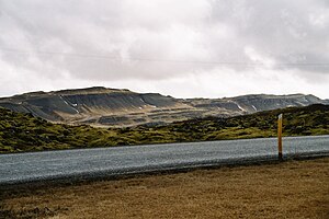
Hallarmúli
| Hallarmúli | ||
|---|---|---|
|
Hallarmúli seen from the Grábrókahraun lava field |
||
| height | 260 m | |
| location | Iceland | |
| Coordinates | 64 ° 44 '11 " N , 21 ° 30' 15" W | |
|
|
||
| Type | extinct central volcano | |
| Last eruption | about 4 million years ago | |
|
Hallarmúli from the air, left. in the middle distance |
||
The Hallarmúli (260 m) is an extinct and heavily eroded volcano in Iceland .
location
The mountain is located in western Iceland about 2 km east of Hringvegur and 30 km north of Borgarnes . In the west it borders on the valley of the Norðurá , in the east on that of the Þverá (Mýrar) .
The university town of Bifröst is about 5 km northwest of Hallarmúli.
geology
They are the eroded remains of a central volcano that was active about four million years ago. He didn't get very far in his development.
literature
- Maryam Khodayar: Geological Map of Hallarmúli Volcano, West Iceland. Scale 1: 20,000. Bedrock Tectonics and Unstable Plate Boundaries. Iceland GeoSurvey, ÍSOR-2009/060. Prepared for Bergsprungur Project. 23 p. + map.
See also
Web links
Individual evidence
- ↑ Iceland. Vega Atlas. Edited by Ferðakort-Verlag. Reykjavík 2006, p. 2.
- ↑ cf. Íslandshandbókin. Náttúra, saga og sérkenni. 1. bindi. Edited by T. Einarsson, H. Magnússon. Reykjavík (Örn og Örlygur) 1989, p. 123
- ↑ cf. Freysteinn Sigurðsson: Borgarfjarðarhérað milli Mýra og Hafnarfjalla. Ferðafélag Íslands. Árbók 2004 , Reykjavík 2004, pp. 31 and 72


