Thèze (river)
| Thèze | ||
|
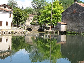
The mouth of the river at Condat |
||
| Data | ||
| Water code | FR : O85-0400 | |
| location | France , Occitania and Nouvelle-Aquitaine regions | |
| River system | Garonne | |
| Drain over | Lot → Garonne → Atlantic Ocean | |
| source | in the municipality of Saint-Caprais, 44 ° 37 ′ 14 ″ N , 1 ° 10 ′ 0 ″ E |
|
| Source height | approx. 221 m | |
| muzzle | at Condat in the municipality of Fumel in the Lot coordinates: 44 ° 29 ′ 45 ″ N , 0 ° 59 ′ 13 ″ E, 44 ° 29 ′ 45 ″ N , 0 ° 59 ′ 13 ″ E |
|
| Mouth height | approx. 67 m | |
| Height difference | approx. 154 m | |
| Bottom slope | approx. 5.7 ‰ | |
| length | 27 km (see notes) | |
| Reservoirs flowed through | Plan d'eau du Moulin du Mas | |
The Thèze is a river in France that runs through the Occitanie and Nouvelle-Aquitaine regions. It rises in the municipality of Saint-Caprais , generally drains in a south-westerly direction and flows into the Lot after 27 kilometers at Condat , in the municipality of Fumel, as a right tributary . On its way, the Thèze touches the Lot and Lot-et-Garonne departments .
Places on the river
- Saint-Caprais
- La Thèze , municipality of Frayssinet-le-Gélat
- Cassagnes
- Montcabrier
- Saint-Martin-le-Redon
- Condat , parish of Fumel
Web links
Commons : Thèze - collection of images, videos and audio files
