Hallett Peninsula
| Hallett Peninsula | ||
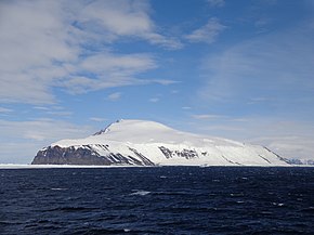
 View from the north of the Hallett Peninsula with Cape Hallett and Mount Geoffrey Markham |
||
| Geographical location | ||
|
|
||
| Coordinates | 72 ° 30 ′ S , 170 ° 10 ′ E | |
| location | Borchgrevink Coast , Victoria Land , East Antarctica | |
| Waters 1 | Ross Sea | |
| Waters 2 | Edisto Inlet | |
| Waters 3 | Tucker Inlet | |
| length | 32 km | |
 Hallett Peninsula topographic map (center right) |
||
The Hallett Peninsula is a triangular and domed peninsula on the Borchgrevink Coast of East Antarctica, Victoria Land . Its cliffs rise up to 1500 m on the east side and up to 300 m in the west . The peninsula stretches from Cape Hallett in the north to Cape Wheatstone in the southeast. It is connected to the mainland by a narrow land bridge between the Tucker Glacier and Edisto Inlet . The highest point is Mount Geoffrey Markham with 1770 m .
Participants of the New Zealand Geological Survey Antarctic Expedition named it after the built at Cape Hallett Hallett station whose namesake Thomas Rawe Hallett's († 1845), a ship's officer at the British Antarctic Expedition (1839-1843) under the direction of James Clark Ross .
Web links
- Hallett Peninsula in the Geographic Names Information System of the United States Geological Survey (English)
- Hallett Peninsula on geographic.org (English)
