Hamarikyu Park

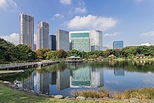
The Hamarikyū Park ( Japanese 浜 離宮 恩賜 庭園 , Hama-rikyū onshi teien , German "Imperial Garden of the Hama Residence") is a park in the Chūō district , Tokyo Japan .
history
Originally, the reed-covered area by the water was used by the Tokugawa as a hunting area. In 1654 Tokugawa Tsunashige (the third son of Tokugawa Iemitsu ) received 15,000 Tsubo from the 4th Shogun Ietsuna . He won land here, although the area is still separated from the mainland by a ditch. The property built there was named after his homeland Kōfu hama-yashiki ( 甲 府 浜 屋 敷 ) or Umite-yashiki ( 海 手 屋 敷 ).
In 1707 the garden was extensively rebuilt for permanent use and the Nakajima, Umite and Kiyomizu tea house, a Kannon-do, Kōshin-do, the main gate and a fixed bridge were built. When Tsunashiges son Ienobu later became the sixth Shogun in 1709, the complex was expanded and called Hama Goten ( 浜 御 殿 ).
In the time of the 8th Shogun Yoshimune (1716-1745) a forge and powder magazines were built in the garden and cannons were set up. In 1727, fires devastated the facility. At the time of the 11th Shogun Ienari (1787–1837), teahouses were built again: Tsubame-no-chaya , Matsu-no-chaya u. a. Rest areas have also been set up.
At the time of Bakumatsu , the facility was no longer used, but in 1866 the commissioner for the Navy ( 海軍 奉行 , Kaigun bugyō ) was based there. A residence was planned for it, but this was no longer implemented due to the fall of the Shogunate in 1868. After the Meiji Restoration , the area fell to the courtyard and has since been called Hama-rikyū , "Hama external residence".
In 1878 the Ministry of Foreign Affairs built a guest house there, called Enryōkan ( 延 遼 館 ). This building (in the plan from 1884 as a three-wing complex), executed as a stone structure, was next to the Rokumeikan a well-known example of the adoption of western architecture. In 1889 the building was demolished. When the former President of the USA General Grant visited Japan on his world tour in 1879, he was received by the Meiji Tennō in the Hama-rikyū in a local tea house .
Buildings were destroyed or damaged in the Kanto earthquake in 1923 and in World War II . In 1946 the park was transferred to the city, which largely restored it. In 1952 the (original) facility was declared a special historical site ( tokubetsu shiseki ).
description
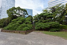
The park with its ponds and teahouses is an important example of the culture of the Edo period , despite the destruction of individual buildings . Located on Tokyo Bay, the ponds are carefully connected to it and thus participate in the ebb and flow of the tide. There are only traces of most of the teahouses, but the rebuilt teahouse on the central island (Nakajima) in the largest pond is still in use today (along with others that have been rebuilt). A specialty of the Hama-rikyū were bird bunks for duck hunting. The larger bunk is closed off with a board wall for nature conservation reasons, the smaller one directly accessible as a relic. At the southern end there is an increase, the "mountain with a view of Mount Fuji " ( 富士 見 山 , Fujimiyama ).
The park is now protected from flooding by a protective wall in front of it.
Access
Visitors can enter the park through the entrance on the north side or take a boat from Asakusa (35 minutes). There is an entrance fee to visit the park.
Characteristics
- Carrier: Tokyo Prefecture.
- Opening: April 1, 1946
- Area: 250,165.81 m², including 81,201 m² of lawn
- Tree population: 6,077 trees (1995)
- Bush population: 2,601 bushes + 41,800 m² bushland
- Facilities: tea houses, kiosk
Remarks
- ↑ KOSHIN or Ka-no-e saru ( 庚申 ) is in the 60-year cycle z. B. the year 1680.
literature
- Leaflet of the park
- Tōkyō-to (ed.): Hama-rikyū onshi teien , in: Toritsu kōen gaido, 1995.
Web links
- Tokyo Metropolitan Park Association
- Hama-rikyu Gardens Gallery
- "Tokyo Cruise Ship (Water Bus)" - Hamarikyu
- Tokyo Metropolitan Park Association
Coordinates: 35 ° 39 ′ 36 ″ N , 139 ° 45 ′ 49 ″ E


