
Caracena
| Caracena municipality | |||
|---|---|---|---|
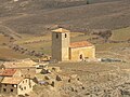
 Caracena - the village with the churches of San Pedro (left) and Santa María (right)
|
|||
| coat of arms | Map of Spain | ||
 Help on coat of arms |
|
||
| Basic data | |||
| Autonomous Community : |
|
||
| Province : | Soria | ||
| Comarca : | Comarca de Tiermes-Caracena | ||
| Coordinates | 41 ° 23 ′ N , 3 ° 5 ′ W | ||
| Height : | 1080 msnm | ||
| Area : | 18.15 km² | ||
| Residents : | 17 (Jan. 1, 2019) | ||
| Population density : | 0.94 inhabitants / km² | ||
| Postal code : | 42311 | ||
| Municipality number ( INE ): | 42052 | ||
| administration | |||
| Website : | Caracena | ||

Caracena is a small mountain village and at the same time the center of a municipality (municipio) with only 17 inhabitants (as of January 1, 2019) in the Spanish province of Soria in the autonomous community of Castile-León . It is particularly worth seeing because of its location, but also because of the two Romanesque churches in the town center, which in 2009 was classified as a cultural asset ( Bien de Interés Cultural ) in the conjunto histórico-artístico category .
location
Caracena is located in the barren mountain landscape in the southwest of the province of Soria at an altitude of approx. 1080 m . The distance to the nearest town, Burgo de Osma , is around 27 km (driving distance) in a northerly direction. Not far from the village rises the Río Caracena , which supplied the place with water for centuries; Some trees even grow in the sheltered valley locations on its banks. Montejo de Tiermes , about 10 km to the west, can be reached on a hike. The climate is temperate to warm; Rain (approx. 511 mm / year) falls over the year.
Population development
| year | 1857 | 1900 | 1950 | 2000 | 2017 |
| Residents | 240 | 169 | 169 | 23 | 13 |
The mechanization of agriculture and the increasing aridity of the mountain region led to a loss of jobs, which in turn triggered a rural exodus. The last place in the valley, Santa María del Val , was completely abandoned in the 1960s.
economy
With the exception of barley , hardly any grain was possible to grow on the barren soils of the cold plateaus of the Soria province . For centuries, the population lived from breeding sheep and goats, whose milk was used to make cheese, which after laborious transport could be sold at the market in Burgo de Osma or exchanged for flour, etc. The wool of the sheep was spun and in winter it was woven into lengths of fabric from which simple clothing was made. Goat hair was only suitable for making weatherproof throws ( ponchos ) or sacks, ropes, etc.

history
The Celts , Romans and Visigoths have left no archaeologically usable traces; it was probably hunters and shepherds who first discovered the high valley. The verifiable history of Caracenas goes back to the Moorish- Islamic period when a watchtower ( atalaya ) was built on a nearby hilltop . In the Middle Ages, Christians from the north but also from the south of the Iberian Peninsula ( Mozarabers ) settled the place. The oldest written evidence of the existence of the place comes from the 12th century. Whether the climate at that time was warmer and / or more rainy cannot be said at the moment - in any case, in 1136 more than 30 hamlets or individual farms belonged to the village of Caracena, in which in the 12th century there was also one in addition to the two Romanesque churches Castle ( castillo ) must have been built, which was later torn down and only rebuilt towards the end of the 15th century. The dispatch of inquisitors is also recorded from this time , as there was at least one synagogue in the village . After that, the sources are silent on the history of the place.

Attractions

Due to the long history and the remoteness of Caracena, several important testimonies of Castilian history have been preserved in the place:

- The three-storey but windowless watchtower (atalaya) from the Moorish period (10th century) rises on a round ground plan on a mountain saddle about 3 km north of the village. It has been preserved up to a height of approx. 8.80 m. The entrance is approx. 2.50 m above ground level and was previously only accessible via a ladder (and / or rope ladder ). The basement was probably used as a store for food and water, the middle floor was the weapons store and the upper floor was the lounge and bedroom.
- The single-nave and almost windowless Romanesque church of San Pedro has a well-preserved south porch ( portico or galería porticada) , as is more common in northern Spain (provinces of Burgos, Soria, but also in the vicinity of Segovia). The purpose of these vestibules is ultimately unclear - weather protection, prayer and walkway or representative entrance to the church and / or a sovereign ambience for a meeting place and courtroom for the male population. The asymmetrically laid out seven-arched vestibule shows a twisted column with four shafts and capitals , as they appear in a very similar way in the cloister (claustro) of the Santo Domingo de Silos monastery located about 70 km (as the crow flies) to the north ; Another arch is on the eastern narrow side of the vestibule. The bell tower of the church rises above a vestibule directly in front of the apse and is accompanied by a round stair tower on its south side.
- The church of Santa María , which stands not far from it and also has a single nave, is about the same size. It has a west tower and a fore choir yoke; however, it lacks the south porch. A portal opened on both sides of the nave: the reserved but finely decorated - now unfortunately bricked up - high Romanesque north portal led to the immediately adjoining cemetery; the rather inconspicuous Romanesque south portal is hidden behind a modern porch. The single-nave church is almost windowless, but the two narrow windows in the apse and in the (later added?) Sacristy are of extraordinary beauty: The apse window has a high Romanesque frame with columns and animal capitals, above which two archivolts with carefully crafted braided ribbon patterns rise ; the frame of the window of the sacristy - made of one stone - is chamfered on the inside ; The inner filling consists of a multiple intertwined infinite braided ribbon motif in the Moorish or Mozarabic style. Similar shapes can be found in two other small windows in the south wall of the church.
Santa María Church

Swirl wheel window
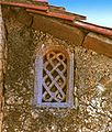
Window with woven tape (celosía)
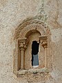
Apse window

Window in the south wall


- The medieval-looking castle ruin (castillo) of Caracena dates from the late 15th century and rises about 500 m south of the town center in rocky terrain high above a gorge. The core building with its square keep (torre del homenaje) is surrounded by an imposing, approximately 300 m long wall secured and stabilized with several semicircular towers . The " Zwinger " located between the two walls has been almost completely preserved.
- In the center of the village there is a square building, which is traditionally called a prison (cárcel) .
- Not far from there is a court pillar (rollo de justítia or picota) from 1738.
- A medieval bridge with only one arch - raised in the middle - spans the Río Caracena a little north of the village , which can swell enormously after prolonged or heavy rains (thunderstorms).

Caracena Castle
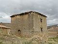
Caracena prison

Court pillar (roller blind)

Bridge over the Caracena River


Web links
- Caracena - floor plans, photos + information (Spanish)
- Caracena - Photos + Info (Spanish)
- Caracena, Church of San Pedro - Photos + Info (Spanish)
- Caracena, Church of San Pedro - floor plan, photos + information (Spanish)
- Caracena, Church of San Pedro - Photos + Info (Spanish)
- Caracena, Santa María Church - Photos + Info (Spanish)
- Catalog of churches with vestibules (Spanish)
Individual evidence
- ↑ Cifras oficiales de población resultantes de la revisión del Padrón municipal a 1 de enero . Population statistics from the Instituto Nacional de Estadística (population update).
- ↑ Caracena - climate tables
- ^ Caracena - population development
- ↑ Caracena - watchtower
- ↑ Caracena - Church of San Pedro
- ↑ Caracena - Santa María Church
- ^ Caracena - Castillo
Abejar | Adradas | Ágreda | Alconaba | Alcubilla de Avellaneda | Alcubilla de las Peñas | Aldeal duck | Aldealices | Aldealpozo | Aldealseñor | Aldehuela de Periáñez | Las Aldehuelas | Alentisque | Aliud | Almajano | Almaluez | Almarza | Almazán | Almazul | Almenar de Soria | Alpanseque | Arancón | Arcos de Jalón | Arenillas | Arévalo de la Sierra | Ausejo de la Sierra | Baraona | Barca | Barcones | Bayubas de Abajo | Bayubas de Arriba | Beratón | Berlanga de Duero | Blacos | Bliecos | Borjabad | Borobia | Buberos | Buitrago | Burgo de Osma-Ciudad de Osma | Cabrejas del Campo | Cabrejas del Pinar | Calatañazor | Caltojar | Candilichera | Cañamaque | Carabantes | Caracena | Carrascosa de Abajo | Carrascosa de la Sierra | Casarejos | Castilfrío de la Sierra | Castillejo de Robledo | Castilruiz | Centenera de Andaluz | Cerbón | Cidones | Cigudosa | Cihuela | Ciria | Cirujales del Río | Coscurita | Covaleda | Cubilla | Cubo de la Solana | Cueva de Ágreda | Dévanos | Deca | Duruelo de la Sierra | Escobosa de Almazán | Espeja de San Marcelino | Espejón | Estepa de San Juan | Frechilla de Almazán | Fresno de Caracena | Fuentearmegil | Fuentecambrón | Fuentecantos | Fuentelmonge | Fuentelsaz de Soria | Fuentepinilla | Fuentes de Magaña | Fuentestrún | Garray | Golmayo | Gómara | Gormaz | Herrera de Soria | Hinojosa del Campo | Langa de Duero | Liceras | La Losilla | Magaña | Maján | Matalebreras | Matamala de Almazán | Medinaceli | Miño de Medinaceli | Miño de San Esteban | Molinos de Duero | Momblona | Monteagudo de las Vicarías | Montejo de Tiermes | Montenegro de Cameros | Morón de Almazán | Muriel de la Fuente | Muriel Viejo | Nafría de Ucero | Narros | Navaleno | Nepas | Nolay | Noviercas | Ólvega | Oncala | Pinilla del Campo | Portillo de Soria | La Póveda de Soria | Pozalmuro | Quintana Redonda | Quintanas de Gormaz | Quiñonería | Los Rábanos | Rebollar | Recuerda | Rello | Renieblas | Retortillo de Soria | Reznos | La Riba de Escalote | Rioseco de Soria | Rollamienta | El Royo | Balance | San Esteban de Gormaz | San Felices | San Leonardo de Yagüe | San Pedro Manrique | Santa Cruz de Yanguas | Santa María de Huerta | Santa María de las Hoyas | Serón de Nágima | Soliedra | Soria | Sotillo del Rincon | Suellacabras | Tajahuerce | Tajueco | Talveila | Tardelcuende | Taroda | Tejado | Torlengua | Torreblacos | Torrubia de Soria | Trévago | Ucero | Vadillo | Valdeavellano de Tera | Valdegeña | Valdelagua del Cerro | Valdemaluque | Valdenebro | Valdeprado | Valderrodilla | Valtajeros | Velamazán | Velilla de la Sierra | Velilla de los Ajos | Viana de Duero | Villaciervos | Villanueva de Gormaz | Villar del Ala | Villar del Campo | Villar del Río | Los Villares de Soria | Villasayas | Villaseca de Arciel | Vinuesa | Vizmanos | Vozmediano | Yanguas | Yelo