Duruelo de la Sierra
| Duruelo de la Sierra municipality | ||
|---|---|---|
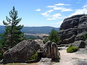
 Duruelo de la Sierra - Mirador de Castroviejo
|
||
| coat of arms | Map of Spain | |

|
|
|
| Basic data | ||
| Autonomous Community : |
|
|
| Province : | Soria | |
| Comarca : | Pinares (comarca) | |
| Coordinates | 41 ° 57 ′ N , 2 ° 56 ′ W | |
| Height : | 1200 msnm | |
| Area : | 44.84 km² | |
| Residents : | 1,090 (Jan 1, 2019) | |
| Population density : | 24.31 inhabitants / km² | |
| Postal code : | 42158 | |
| Municipality number ( INE ): | 42078 | |
| administration | ||
| Website : | Duruelo de la Sierra | |
Duruelo de la Sierra is a place and at the same time the center of a municipality (municipio) belonging to the poorly populated Serranía Celtibérica with 1,090 inhabitants (as of January 1, 2019) in the Spanish province of Soria in the autonomous community of Castile-León . The parish belongs to the Diocese of Osma-Soria .
location
The place Duruelo de la Sierra is located approx. 10 km southwest of the 2228 m high Pico de Urbión on the upper reaches of the Duero in the barren mountain landscape in the extreme northwest of the Soria province near the borders with the province of Burgos and the La Rioja region at an altitude of approx. 1200 m . The provincial capital Soria is located about 55 km (driving distance) southeast. The climate is harsh, sometimes temperate to warm; Rain (approx. 625 mm / year) falls over the year.
Population development
| year | 1857 | 1900 | 1950 | 2000 | 2018 |
| Residents | 551 | 530 | 1,199 | 1,452 | 1,111 |
Duruelo de la Sierra is one of the few mountain towns in the province of Soria with a growing or almost constant population.
economy
Duruelo de la Sierra is located on the former road between Soria and Burgos , which is still used today . In addition to the usual self-sufficiency economy, goods and ideas came to the small town, where traders, craftsmen and service providers settled. Today summer tourism also plays a not insignificant role in the economic life of the municipality.
history
Bronze Age and Celtiberian traces can be found in the region . The Romans , Visigoths and Moors , on the other hand, left no archaeologically usable traces. Around the year 900 the sparsely populated area, which was mainly visited by shepherds, was recaptured by the Christians ( reconquista ) . After that, immigrants from the north but also from the south ( Mozarabs ) of the Iberian Peninsula settled the region.
Attractions
- The Iglesia de San Miguel Arcángel is dedicated to the Archangel Michael ; it is a single-nave building with remains of a previous church and a bell tower (campanario) on the south side ; the main entrance is also on the south side. During excavations, several sarcophagi and stone box graves from the time of the 9th to 12th centuries were discovered in the vicinity of the church .
- Surroundings
- The main destination of excursions and hikes in the area is the rocky landscape of Castroviejo, about 8 km north of the village .
- In the nearby rock cave of Cueva Serena there is a small but permanent waterfall (cascada) .
Web links
Individual evidence
- ↑ Cifras oficiales de población resultantes de la revisión del Padrón municipal a 1 de enero . Population statistics from the Instituto Nacional de Estadística (population update).
- ↑ Duruelo de la Sierra / Covaleda - climate tables
- ↑ Duruelo de la Sierra - population development
- ↑ Duruelo de la Sierra - History
- ↑ Duruelo de la Sierra - Church
- ↑ Duruelo de la Sierra - the rocky landscape of Castroviejo
- ↑ Duruelo de la Sierra - the rocky landscape of Castroviejo
