
Almarza
| Almarza municipality | |||
|---|---|---|---|
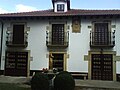
 Almarza - Iglesia de San Gregorio and Casa Fuerte
|
|||
| coat of arms | Map of Spain | ||

|
|
||
| Basic data | |||
| Autonomous Community : |
|
||
| Province : | Soria | ||
| Comarca : | El Valle (Soria) | ||
| Coordinates | 41 ° 57 ′ N , 2 ° 28 ′ W | ||
| Height : | 1150 msnm | ||
| Area : | 101.13 km² | ||
| Residents : | 591 (Jan. 1, 2019) | ||
| Population density : | 5.84 inhabitants / km² | ||
| Postal code : | 42169 | ||
| Municipality number ( INE ): | 42019 | ||
| administration | |||
| Website : | Almarza | ||

Almarza is a place and a mountain community ( municipio ) with only 591 inhabitants (as of January 1, 2019) in the northwest of the Spanish province of Soria in the autonomous community of Castile and León . The municipality includes about a dozen villages and hamlets that were incorporated into the 1960s, but two of them are already completely depopulated ( despoblados ) .
Location and climate
The municipality of Almarza is located in the mountain landscape in the north of the province of Soria at an altitude of approx. 1050 to 1150 m . The distance to the southern provincial capital Soria is approx. 23 km (driving distance). The climate is temperate to warm; Rain (approx. 620 mm / year) falls over the year.
Population development
| year | 1857 | 1900 | 1950 | 2000 | 2017 |
| Residents | 436 | 514 | 518 | 615 | 604 |
The increasing mechanization of agriculture and the resulting loss of jobs led to a significant decline in the population in the second half of the 20th century, which, however, could be absorbed by incorporation.
economy
The place Almarza served for centuries as a trade, handicraft and service center for the agricultural villages and farmsteads in the area. It was also an important station in the system of trade and livestock routes ( Cabaña Real de Carreteros ) in northern Spain. Today tourism in the form of rental of holiday homes (casas rurales) plays a not insignificant role for the income of the municipality.
history
In the village of Cubo de la Sierra a Neolithic large stone grave ( Dolmen de San Gregorio ) was uncovered, which dates from around 3500 to 4000 BC. Is dated. From the Celtiberian era (6th to 2nd century BC) there are two ramparts identified as castra ; The bridge in the village of Espejo de Tera , known as puente romano , may still come from Roman times . After the Arab-Moorish conquest , large areas in the north of the Iberian Peninsula were depopulated and were only repopulated by Christians from the north in the 10th and 11th centuries ( repoblación ) ; the first Romanesque churches were built in the 12th century . From the 16th to the 18th century, the region experienced an economic boom due to the export of wool to Flanders , which can be seen in the renovation or construction of several churches.
Attractions

- Almarza
- The Casa Fuerte de San Gregorio is an extraordinary late medieval building complex consisting of a church (Iglesia de San Gregorio) and a monastery, which was handed over to the Dominican order in the 16th century .
- The parish church ( Iglesia de Santa Lucía ), built entirely from stone with the exception of a few corner stones, is a single-nave building in the transitional style between the late Gothic and Renaissance ; it had a previous Romanesque building, of which only small traces have been preserved. The late Baroque altarpiece shows columns entwined with wine and pilasters in the Churrigueresque style on top .
- The Ermita de la Inmaculada Concepción has an octagonal floor plan, which is unusual for the region.
- The Ermita de los Santos Nuevos baroque coats of arms (blasones) of the Marqueses de Zafra .
- The Palacio de la Familia Montenegro is a remarkable building from the 18th century.
Palace with heraldic shield

baroque noble coat of arms


- Cubo de la Sierra
- The Casa Fuerte is a late Gothic building from 1461; it belonged to the Medrano family.
- The Iglesia de Santo Tomás Apóstol is a building from the 18th century; the Romanesque apse is still preserved.
- The remains of the megalithic Dolmen de San Gregorio are not far from today's location.
- Espejo de Tera
- On the outskirts there is a bridge called puente romano .
- The unadorned Romanesque village church of San Bonifacio is largely unchanged.
- Gallinero
- In the rural Gothic Iglesia de Nuestra Señora del Rosario there are graves and coats of arms of the Vinuesa family.
- The Casa gótica de los Vinuesa is an important testimony to late Gothic civil architecture.
- Dinosaur tracks can be found on rock slabs in the area ( Yacimento de Icnitas ).
- Barely noticeable remains of a Celtiberian castrum can be found in the area.
- Matute de la Sierra
- The small Romanesque village church houses a baptismal font that is well worth seeing .
- Portelárbol
- The Iglesia Santo Tomás Apóstol is Romanesque.
- San Andrés de Soria
- The Iglesia de San Andrés is a building from the late Gothic period; traces of a Romanesque predecessor church can be seen on the portal.
- Segovela
- The Iglesia de la Santa Cruz , which was largely rebuilt in the 18th century , still has its Romanesque apse.
- Sepúlveda de la Sierra
- At the later renewed church of Santo Tomás Apóstol a beautiful Romanesque portal surprises.
- In the vicinity is the Castro celtíbero del Zaranzano
- Tera
- At the late Gothic Iglesia de Nuestra Señora de Carmen , remains of a previous Romanesque building can still be seen.
- The Casa Solariega de los Marqueses de Vadillo dates from the 15th century.
Web links
- Almarza, history - photo + info (Spanish)
- Almarza, sights - photos + information (Spanish)
Individual evidence
- ↑ Cifras oficiales de población resultantes de la revisión del Padrón municipal a 1 de enero . Population statistics from the Instituto Nacional de Estadística (population update).
- ↑ Almarza - climate tables
- ↑ Almarza - population development
- ↑ Almarza - monastery
- ↑ Almarza - Dolmen de San Gregorio
Abejar | Adradas | Ágreda | Alconaba | Alcubilla de Avellaneda | Alcubilla de las Peñas | Aldeal duck | Aldealices | Aldealpozo | Aldealseñor | Aldehuela de Periáñez | Las Aldehuelas | Alentisque | Aliud | Almajano | Almaluez | Almarza | Almazán | Almazul | Almenar de Soria | Alpanseque | Arancón | Arcos de Jalón | Arenillas | Arévalo de la Sierra | Ausejo de la Sierra | Baraona | Barca | Barcones | Bayubas de Abajo | Bayubas de Arriba | Beratón | Berlanga de Duero | Blacos | Bliecos | Borjabad | Borobia | Buberos | Buitrago | Burgo de Osma-Ciudad de Osma | Cabrejas del Campo | Cabrejas del Pinar | Calatañazor | Caltojar | Candilichera | Cañamaque | Carabantes | Caracena | Carrascosa de Abajo | Carrascosa de la Sierra | Casarejos | Castilfrío de la Sierra | Castillejo de Robledo | Castilruiz | Centenera de Andaluz | Cerbón | Cidones | Cigudosa | Cihuela | Ciria | Cirujales del Río | Coscurita | Covaleda | Cubilla | Cubo de la Solana | Cueva de Ágreda | Dévanos | Deca | Duruelo de la Sierra | Escobosa de Almazán | Espeja de San Marcelino | Espejón | Estepa de San Juan | Frechilla de Almazán | Fresno de Caracena | Fuentearmegil | Fuentecambrón | Fuentecantos | Fuentelmonge | Fuentelsaz de Soria | Fuentepinilla | Fuentes de Magaña | Fuentestrún | Garray | Golmayo | Gómara | Gormaz | Herrera de Soria | Hinojosa del Campo | Langa de Duero | Liceras | La Losilla | Magaña | Maján | Matalebreras | Matamala de Almazán | Medinaceli | Miño de Medinaceli | Miño de San Esteban | Molinos de Duero | Momblona | Monteagudo de las Vicarías | Montejo de Tiermes | Montenegro de Cameros | Morón de Almazán | Muriel de la Fuente | Muriel Viejo | Nafría de Ucero | Narros | Navaleno | Nepas | Nolay | Noviercas | Ólvega | Oncala | Pinilla del Campo | Portillo de Soria | La Póveda de Soria | Pozalmuro | Quintana Redonda | Quintanas de Gormaz | Quiñonería | Los Rábanos | Rebollar | Recuerda | Rello | Renieblas | Retortillo de Soria | Reznos | La Riba de Escalote | Rioseco de Soria | Rollamienta | El Royo | Balance | San Esteban de Gormaz | San Felices | San Leonardo de Yagüe | San Pedro Manrique | Santa Cruz de Yanguas | Santa María de Huerta | Santa María de las Hoyas | Serón de Nágima | Soliedra | Soria | Sotillo del Rincon | Suellacabras | Tajahuerce | Tajueco | Talveila | Tardelcuende | Taroda | Tejado | Torlengua | Torreblacos | Torrubia de Soria | Trévago | Ucero | Vadillo | Valdeavellano de Tera | Valdegeña | Valdelagua del Cerro | Valdemaluque | Valdenebro | Valdeprado | Valderrodilla | Valtajeros | Velamazán | Velilla de la Sierra | Velilla de los Ajos | Viana de Duero | Villaciervos | Villanueva de Gormaz | Villar del Ala | Villar del Campo | Villar del Río | Los Villares de Soria | Villasayas | Villaseca de Arciel | Vinuesa | Vizmanos | Vozmediano | Yanguas | Yelo