
El Burgo de Osma-Ciudad de Osma
| Municipality of El Burgo de Osma - Ciudad de Osma | |||
|---|---|---|---|
 El Burgo de Osma - city walls and tower of the cathedral
|
|||
| coat of arms | Map of Spain | ||

|
|
||
| Basic data | |||
| Autonomous Community : |
|
||
| Province : | Soria | ||
| Comarca : | Tierras del Burgo | ||
| Coordinates | 41 ° 35 ′ N , 3 ° 4 ′ W | ||
| Height : | 906 msnm | ||
| Area : | 289.35 km² | ||
| Residents : | 4,940 (Jan 1, 2019) | ||
| Population density : | 17.07 inhabitants / km² | ||
| Postal code : | 42300 | ||
| Municipality number ( INE ): | 42043 | ||
| administration | |||
| Website : | El Burgo de Osma | ||


El Burgo de Osma-Ciudad de Osma (often just called El Burgo de Osma ) is a Spanish municipality in the southwest of the province of Soria in the autonomous region of Castile and León . It has 4940 inhabitants (as of January 1, 2019), making it the third largest municipality in the province after Soria and Almazán . The city is the seat of the Roman Catholic Diocese of Osma-Soria , which in turn belongs to the Archdiocese of Burgos .
El Burgo de Osma has been recognized as a place of special tourist interest ( Villa de Interés Turístico ) since 1962, and the medieval town center has been classified as a cultural asset ( Bien de Interés Cultural ) in the conjunto histórico-artístico category since 1993 .
location
The village, located about 900 meters above sea level, comprises two parts - the medieval El Burgo de Osma is located northeast of the confluence of the Río Abión with the Río Lobos , a tributary of the Duero . The smaller new town Ciudad de Osma is located on the west bank of the Río Lobos .
The provincial capital Soria is about 60 kilometers (driving distance) to the northeast. Also worth seeing are the listed places of San Esteban de Gormaz (approx. 12 kilometers to the west) and Berlanga de Duero (approx. 25 kilometers to the southeast) as well as the village of Ucero, about 19 kilometers to the north .
Population development
| year | 1960 | 1970 | 1981 | 1991 | 2001 | 2010 |
| Residents | 3,041 | 5,908 | 4,996 | 5,054 | 5,027 | 5,287 |
From 1850 to 1950, El Burgo de Osma consistently had between 3,000 and 4,000 inhabitants. The population increase between 1960 and 1970 is due to the incorporation of 13 villages and smaller rural communities ( aldeas ).
economy
In the Middle Ages, Burgo de Osma was the religious-cultural and artisanal and economic center of the communities in the surrounding area - a position that it has maintained to this day. In the 1990s, an industrial area ( Polígono Industrial 'LAGÜERA') was created in the south of the city .
history

The name 'Osma' is derived from the name of the Celtiberian (more precisely Arevak ) settlement on a hill west of today's city , which was founded in 99 BC. BC was conquered by the Romans and was given the name Uxama Argaela . A few years later (72 BC) Uxama was destroyed by the troops of Gnaeus Pompeius Magnus after an uprising , but was then rebuilt. Under the Visigoths , Oxoma or Osoma became a bishopric in 597.
In the early 8th century, Uxama , like almost the entire Iberian Peninsula , fell into the hands of Muslim conquerors and was then given the name Waxsima . Already in 912 the Castilian Count Gonzalo Téllez succeeded in the temporary reconquest ( reconquista ). In the same year the construction of a fortification began, but as early as 934 the place came under Muslim rule again, only to finally fall under Castilian suzerainty at the beginning of the following century .
Between the years 1101 and 1109, Pedro de Bourges , who is venerated today under the name of San Pedro de Osma as the city's patron saint, held the office of bishop. He ordered the construction of a Romanesque cathedral on the site of today's settlement - at that time a suburb of Uxamas . A settlement ( burgo ), independent of Uxama and apparently fortified , soon developed around the cathedral , which was henceforth called 'Osma'. While Burgo de Osma flourished, ancient Uxama fell and was eventually abandoned entirely.
Around the middle of the 13th century the Romanesque cathedral was demolished and replaced by a new Gothic building, which was only completed around 100 years later (1361) and still forms the main part of the church structure today. The partially preserved city wall was built in the 15th century. The University ( Pontificia y Real Universidad de Santa Catalina ) was founded by Bishop Pedro Álvarez de Acosta around the middle of the 16th century.
In 1808, Burgo de Osma was occupied by the Napoleonic troops under Marshal Ney . During the first Carlist War (1833-1840) the site was the scene of renewed clashes.
- Aeródromo de La Rasa
In the district of La Rasa , seven kilometers to the south, there used to be an airfield. During the civil war , La Rasa was the deployment site of the German Condor u. a. during the war in the north . Here were parts of Kampfgruppe 88 (K / 88), which was equipped with Heinkel He 111 ( Pedro ) and also Messerschmitt Bf 109 of Jagdgruppe 88 (J / 88) and Dornier Do 17 ( Bacalao ) of reconnaissance squadron 88 (A / 88) .
Attractions
.jpg)

._Patio.jpg)
- The Cathedral of Santa María de la Asunción essentially comes from the Gothic era, although Baroque elements can be seen both on the tower and inside.
- The bishop's palace ( palacio episcopal ) has a simple, yet eye-catching portal with jagged arches and an alfiz edging.
- The Plaza Mayor with its façades supported by pillars formed the cultural and mercantile center of the medieval and early modern city. Here - opposite the Hospital de San Agustín - is also the town hall ( ayuntamiento ) , built in 1771 in the late Mudéjar style , with its galleries opening onto the square, above which a clock and a bell rise.
- The Hospital de San Agustín , built towards the end of the 17th century, is particularly noteworthy for its facade, which has clear echoes of the architecture of the Herrera style ; it is now used as an urban cultural center and houses a collection of modern art.
- The Carmelite Convent ( Convento del Carmen ) was built in 1607; Inside, a statue of the Madonna ( Virgen del Carmen ) is venerated. The organ from the beginning of the 19th century comes from the French Carmelite convent of Agen .
- outside
- Those from the 15./16. The ruins of a century castle ( Castillo de Osma ) rise on a hill east of the city.
- On a hill west of the city are the ruins of ancient Uxama ; a museum ( Museo de Uxama ) with finds from the Roman settlement is also available.
- Not far from there, a watchtower ( Atalaya ) reminds of the time of Islamic dominance over the area. Other watchtowers ( Atalaya de Valdenarro , Atalaya de El Lomero and others) are located at intervals of two to three kilometers in the vicinity of El Burgo de Osma.

Portal of the Episcopal Palace

Castillo de Osma
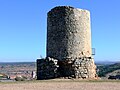
Atalaya de Uxama


Town twinning
Personalities
- Manuel Ruiz Zorrilla (1833–1895), Spanish politician
- Marcelino Camacho (1918–2010), politician and trade unionist
- Jesús Gil (1933–2004), Spanish politician and entrepreneur
Web links
- El Burgo de Osma, historical buildings - photos + information (Spanish)
- El Burgo de Osma - Photos + Info (Spanish)
- El Burgo de Osma - Video (Spanish)
Individual evidence
- ↑ Cifras oficiales de población resultantes de la revisión del Padrón municipal a 1 de enero . Population statistics from the Instituto Nacional de Estadística (population update).
Abejar | Adradas | Ágreda | Alconaba | Alcubilla de Avellaneda | Alcubilla de las Peñas | Aldeal duck | Aldealices | Aldealpozo | Aldealseñor | Aldehuela de Periáñez | Las Aldehuelas | Alentisque | Aliud | Almajano | Almaluez | Almarza | Almazán | Almazul | Almenar de Soria | Alpanseque | Arancón | Arcos de Jalón | Arenillas | Arévalo de la Sierra | Ausejo de la Sierra | Baraona | Barca | Barcones | Bayubas de Abajo | Bayubas de Arriba | Beratón | Berlanga de Duero | Blacos | Bliecos | Borjabad | Borobia | Buberos | Buitrago | Burgo de Osma-Ciudad de Osma | Cabrejas del Campo | Cabrejas del Pinar | Calatañazor | Caltojar | Candilichera | Cañamaque | Carabantes | Caracena | Carrascosa de Abajo | Carrascosa de la Sierra | Casarejos | Castilfrío de la Sierra | Castillejo de Robledo | Castilruiz | Centenera de Andaluz | Cerbón | Cidones | Cigudosa | Cihuela | Ciria | Cirujales del Río | Coscurita | Covaleda | Cubilla | Cubo de la Solana | Cueva de Ágreda | Dévanos | Deca | Duruelo de la Sierra | Escobosa de Almazán | Espeja de San Marcelino | Espejón | Estepa de San Juan | Frechilla de Almazán | Fresno de Caracena | Fuentearmegil | Fuentecambrón | Fuentecantos | Fuentelmonge | Fuentelsaz de Soria | Fuentepinilla | Fuentes de Magaña | Fuentestrún | Garray | Golmayo | Gómara | Gormaz | Herrera de Soria | Hinojosa del Campo | Langa de Duero | Liceras | La Losilla | Magaña | Maján | Matalebreras | Matamala de Almazán | Medinaceli | Miño de Medinaceli | Miño de San Esteban | Molinos de Duero | Momblona | Monteagudo de las Vicarías | Montejo de Tiermes | Montenegro de Cameros | Morón de Almazán | Muriel de la Fuente | Muriel Viejo | Nafría de Ucero | Narros | Navaleno | Nepas | Nolay | Noviercas | Ólvega | Oncala | Pinilla del Campo | Portillo de Soria | La Póveda de Soria | Pozalmuro | Quintana Redonda | Quintanas de Gormaz | Quiñonería | Los Rábanos | Rebollar | Recuerda | Rello | Renieblas | Retortillo de Soria | Reznos | La Riba de Escalote | Rioseco de Soria | Rollamienta | El Royo | Balance | San Esteban de Gormaz | San Felices | San Leonardo de Yagüe | San Pedro Manrique | Santa Cruz de Yanguas | Santa María de Huerta | Santa María de las Hoyas | Serón de Nágima | Soliedra | Soria | Sotillo del Rincon | Suellacabras | Tajahuerce | Tajueco | Talveila | Tardelcuende | Taroda | Tejado | Torlengua | Torreblacos | Torrubia de Soria | Trévago | Ucero | Vadillo | Valdeavellano de Tera | Valdegeña | Valdelagua del Cerro | Valdemaluque | Valdenebro | Valdeprado | Valderrodilla | Valtajeros | Velamazán | Velilla de la Sierra | Velilla de los Ajos | Viana de Duero | Villaciervos | Villanueva de Gormaz | Villar del Ala | Villar del Campo | Villar del Río | Los Villares de Soria | Villasayas | Villaseca de Arciel | Vinuesa | Vizmanos | Vozmediano | Yanguas | Yelo