Carrascosa de la Sierra
| Carrascosa de la Sierra municipality | ||
|---|---|---|
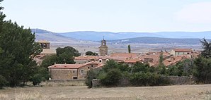
 Carrascosa de la Sierra - town view
|
||
| coat of arms | Map of Spain | |
 Help on coat of arms |
|
|
| Basic data | ||
| Autonomous Community : |
|
|
| Province : | Soria | |
| Comarca : | Tierras Altas | |
| Coordinates | 41 ° 54 ′ N , 2 ° 17 ′ W | |
| Height : | 1185 msnm | |
| Area : | 12.76 km² | |
| Residents : | 19 (Jan. 1, 2019) | |
| Population density : | 1.49 inhabitants / km² | |
| Postal code : | 42180 | |
| Municipality number ( INE ): | 42054 | |
| administration | ||
| Website : | Carrascosa de la Sierra | |
Carrascosa de la Sierra is a small mountain village and at the same time the center of a municipality ( municipio ) with only 19 inhabitants (as of January 1, 2019) in the Spanish province of Soria in the autonomous community of Castile-León . The parish belongs to the Diocese of Osma-Soria .
location
The town and municipality of Carrascosa de la Sierra are located in the barren mountain landscape north of the Duero in the extreme north of the Soria province at an altitude of approx. 1185 m . The provincial capital Soria is located about 28 km (driving distance) southwest. The climate is harsh, sometimes temperate to warm; Rain (approx. 635 mm / year) falls over the year.
Population development
| year | 1857 | 1900 | 1950 | 2001 | 2011 |
| Residents | 222 | 238 | 220 | 13 | 20th |
The mechanization of agriculture and the increasing aridity of the mountain region led to a loss of jobs in the second half of the 20th century, which in turn triggered a rural exodus.
economy
With the exception of barley , hardly any grain was possible to grow on the barren soils of the plateaus of the province of Soria, which are cold in winter . For centuries, the population lived mainly from breeding sheep and goats, whose milk was used to make cheese, which, after laborious transport, could be sold at the market in Soria or exchanged for flour, etc. The wool of the sheep was spun and in winter it was woven into lengths of fabric from which simple clothing was made. Goat hair was only suitable for making weatherproof throws ( ponchos ) or sacks, ropes, etc.
history
The Celts , Romans and Visigoths left no archaeological traces in the area. The verifiable history of the place only goes back to the 16th century; During this time, Christians from the north but also from the south of the Iberian Peninsula populated the region. The place has belonged to the Dukes of Alba since the 16th century .
Attractions
- Most of the houses in the village are made of field stones .
- The small, in part Romanesque acting Iglesia de San Juan Bautista is John the Baptist ordained; it was rebuilt or rebuilt at the time the town was founded. The entrance is on the south side. The church has a total of 7 altars.
- The clock tower with a sundial was built in the 18th century. It is crowned by a small bell gable (espadaña) .
- To the left of this is a small court column (rollo or picota) with the year 1783.
- A spring intake (fuente) is located a little below the village .
- There is also a covered washing area (lavadero) .
- Surroundings
- On the border with the neighboring municipality of Castilfrío de la Sierra there are the remains of a large stone grave ( Dolmen Alto de la Tejera) from the Neolithic Age . It is the only evidence from the time of the megalithic cultures in the province of Soria.
Web links
- Carrascosa de la Sierra, history - photos and information (Spanish)
- Carrascosa de la Sierra, sights - photos and quick facts (spanish)
- Carrascosa de la Sierra, sights - photos and quick facts (spanish)
Individual evidence
- ↑ Cifras oficiales de población resultantes de la revisión del Padrón municipal a 1 de enero . Population statistics from the Instituto Nacional de Estadística (population update).
- ↑ Carrascosa de la Sierra - climate tables
- ↑ Carrascosa de la Sierra - Dolmen


