Santa María de Huerta
| Santa María de Huerta municipality | ||
|---|---|---|
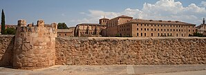
 Santa María de Huerta - Monastery
|
||
| coat of arms | Map of Spain | |

|
|
|
| Basic data | ||
| Autonomous Community : | Castile and Leon | |
| Province : | Soria | |
| Comarca : | Campo de Gómara | |
| Coordinates | 41 ° 16 ′ N , 2 ° 11 ′ W | |
| Height : | 760 msnm | |
| Area : | 49.15 km² | |
| Residents : | 266 (Jan. 1, 2019) | |
| Population density : | 5.41 inhabitants / km² | |
| Postal code : | 42260 | |
| Municipality number ( INE ): | 42167 | |
| administration | ||
| Website : | Santa María de Huerta | |
Santa María de Huerta is a place and a municipality (municipio) with a total of 266 inhabitants (at January 1, 2019) in the southeastern province of Soria and the autonomous community of Castile and Leon in Spain .
Location and climate
Santa María de Huerta is located on the Río Jalón , a tributary of the Ebro , a good 80 km (driving distance) southeast of the provincial capital Soria at an altitude of about 760 m . The historically and culturally significant town of Medinaceli is located a good 30 km southwest. The climate is harsh in winter, but temperate to warm in summer; Rain (approx. 430 mm / year) falls over the year.
Population development
| year | 1857 | 1900 | 1950 | 2000 | 2017 |
| Residents | 332 | 573 | 1,232 | 449 | 285 |
As a result of increasing drought, the mechanization of agriculture , the abandonment of numerous small farms and the resulting lower demand for labor, the number of inhabitants has steadily declined since the middle of the 20th century.
economy
Agriculture, including dairy and pasture farming, played the most important role in the community's predominantly self - sufficient economic life for centuries . Dealers, craftsmen and service providers of all kinds have settled in the town itself. Since the 1970s tourism has become increasingly important in economic life.
history
On a hilltop near the village there are ruins of large stone blocks, some of which have been hewn, the age and purpose of which are indefinite; they are associated with a Celtiberian castrum . Romans, Visigoths and even the Moors left no traces and so the actual history of the rather remote place very likely only begins with the foundation of the Cistercian monastery in 1144. For its construction and maintenance, the monks sometimes resorted to auxiliary workers, who gradually also made up settled in the vicinity of the monastery. In 1886 King Alfonso XIII called. in favor of Antonio María del Valle y Serrano the Marquisate of Villa-Huerta (Marquesado de Villa-Huerta) into being.
Attractions
- The Huerta Monastery was founded in 1144 and has largely been preserved in its original state. It was disbanded in 1833 as a result of the dismortment . In 1930 it was taken over by the Trappist Order .
- The Casa Palacio de la Marquesa de Villa Huerta is a crenellated single-storey building from the late 19th century.
- Surroundings
- Approx. 2 km south of the village are the ruins of the Castillo de Belimbre , almost nothing is known about its construction time and further history.
- The hill with the remains of the Celtiberian fortress can be climbed directly on the border with Aragon.
Web links
- Santa María de Huerta - Photos + Info (Spanish)
Individual evidence
- ↑ Cifras oficiales de población resultantes de la revisión del Padrón municipal a 1 de enero . Population statistics from the Instituto Nacional de Estadística (population update).
- ↑ Santa María de Huerta - Climate tables
- ↑ Santa María de Huerta - Population development
- ↑ Santa María de Huerta - Monastery
- ↑ Santa María de Huerta - Castillo de Belimbre
- ↑ Santa María de Huerta - Castillo de Belimbre

