Cubo de la Solana
| Cubo de la Solana municipality | ||
|---|---|---|
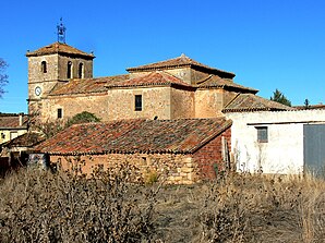
 Cubo de la Solana - Church of San Martín
|
||
| coat of arms | Map of Spain | |

|
|
|
| Basic data | ||
| Autonomous Community : |
|
|
| Province : | Soria | |
| Comarca : | Comarca de Soria | |
| Coordinates | 41 ° 36 ′ N , 2 ° 25 ′ W | |
| Height : | 992 msnm | |
| Area : | 132.84 km² | |
| Residents : | 184 (Jan. 1, 2019) | |
| Population density : | 1.39 inhabitants / km² | |
| Postal code : | 42191 | |
| Municipality number ( INE ): | 42071 | |
| administration | ||
| Website : | www.cubodelasolana.es | |
Cubo de la Solana refers to a place and a municipality ( municipio ) with 184 inhabitants (as of January 1, 2019) in the south of the province of Soria in the autonomous community of Castile-León . Another four hamlets ( Almarail, Ituero, Lubia, Rabanera del Campo ) and the now abandoned Riotuerto belong to the municipality . The Catholic parish belongs to the Diocese of Osma-Soria .
location
The place Cubo de la Solana is located in the plateau interspersed with rocks and hills in the center of the province of Soria at an altitude of approx. 990 meters above sea level. d. M. The distance to the northern provincial capital Soria is approx. 23 kilometers (driving distance). The small but historically significant town of Almazán is only about 18 kilometers to the south-west.
Population development
| year | 1960 | 1970 | 1981 | 1991 | 2001 | 2010 |
| Residents | 540 | 482 | 413 | 296 | 241 | 210 |
In the first half of the 20th century, the community usually had between 580 and 750 inhabitants. The increasing mechanization of agriculture and the resulting loss of jobs have contributed to a large extent to the significant decline in the population in recent decades.
economy
For centuries the community lived exclusively from growing grain ( barley and wheat ), which was mainly operated for self-sufficiency ; livestock farming ( sheep , goats , chickens ) also took place to a small extent. The place Cubo de la Solana served as a mercantile, artisanal and cultural center for the hamlets and farmsteads in its area, which have now mostly disappeared. Today agriculture still plays the most important role, but there is also marginal income from tourism (rental of holiday homes).
history
Traces of a Celtiberian ring wall ( castrum ) were discovered in the municipality ; in Roman times a road ran through the area. After the Arab-Moorish conquest , large areas in the north of the Iberian Peninsula were depopulated . In the 10th century began under the Castilian Count Gonzalo Téllez in the second half of the 11th century under Alfonso VI. Complete reconquest ( reconquista ) of Old Castile , which culminated in the capture of the city of Toledo, about 250 kilometers further south-west, in 1085. During this time Barca was repopulated or repopulated ( repoblación ) by settlers from the Christian north .
Attractions
- The jewel of the place is the parish church ( Iglesia de San Martín ) built entirely from rubble stones over a previous Romanesque building in the 19th century - with the exception of the corner stones . The church building has a straight choir closure , a transept and a west tower and gives a more medieval impression overall. Only the stone baptismal font remained from the previous building.
- The Ermita de la Virgen de la Solana , which is about one kilometer outside the village, is elevated by a bell gable ( espadaña ).
- The Casa palacio del Conde de Gómara originally dates from the 14th century; However, it was changed several times in later times and is privately owned.
Web links
Individual evidence
- ↑ Cifras oficiales de población resultantes de la revisión del Padrón municipal a 1 de enero . Population statistics from the Instituto Nacional de Estadística (population update).
