
Ucero
| Ucero municipality | |||
|---|---|---|---|
 Ucero - the townscape
|
|||
| coat of arms | Map of Spain | ||
 Help on coat of arms |
|
||
| Basic data | |||
| Autonomous Community : |
|
||
| Province : | Soria | ||
| Comarca : | Burgo de Osma | ||
| Coordinates | 41 ° 43 ′ N , 3 ° 3 ′ W | ||
| Height : | 964 msnm | ||
| Area : | 64.53 km² | ||
| Residents : | 50 (Jan. 1, 2019) | ||
| Population density : | 0.77 inhabitants / km² | ||
| Postal code : | 42317 | ||
| Municipality number ( INE ): | 42189 | ||
| administration | |||
| Website : | Ucero | ||

Ucero is a place and a municipality ( municipio ) with 50 inhabitants (as of January 1, 2019) in the Spanish province of Soria in the autonomous region of Castile-León . The place has been recognized as a cultural asset ( Bien de Interés Cultural ) in the Conjunto histórico-artístico category .
location
Ucero is located on the Río Lobos , which is sometimes also called Río Ucero in the following, at the southern end of the rugged mountain landscape of the Parque natural del Cañón del Río Lobos at an altitude of about 970 meters above sea level. d. M. The next larger town, El Burgo de Osma , is about 16 kilometers (driving distance) to the south. To the provincial capital Soria it is about 65 kilometers (driving distance) in an easterly direction. The listed places of San Esteban de Gormaz (27 kilometers southwest) and Berlanga de Duero (40 kilometers southeast) are also worth seeing .
Population development
| year | 1960 | 1970 | 1981 | 1991 | 2001 | 2010 |
| Residents | 203 | 147 | 131 | 102 | 104 | 100 |
In the 19th century, Ucero always had between 150 and 300 inhabitants. As a result of the mechanization of agriculture and the resulting lower demand for labor, the number of inhabitants has been declining since the middle of the 20th century.
economy
The small town was and is largely characterized by agriculture; Mainly wheat and barley are grown . Tourism (hiking and holiday apartments) has played an important role as a source of income for the community since the middle of the 20th century.
history
In the caves and overhangs of the rugged mountain landscape in the north of Ucero, traces of human presence in prehistoric times were found. The first mention of the name 'Ucero' can be found in a document from 1157; a castle ( castillo ) was - according to current knowledge - only built in the 13th century. A certain Juan González de Ucero took part on the side of King Alfonso VIII in the victorious battle of Las Navas de Tolosa (1212) and was rewarded for his services with the manorial rule ( señorio ) over the place. The presence of the Templars at this time is also documented, but it is unclear what property the knightly order, dissolved by Pope Clement V in 1312, had in this area. In any case, in 1302, the then bishop of Osma acquired the place along with 13 neighboring villages or hamlets ( aldeas ). The castle was renewed in the 16th century.
Attractions
- The Parque natural del Cañón del Río Lobos , established in 1985, is an important nature reserve, in which birds ( vultures , falcons , eagles , hawks and sparrowhawks ) as well as small mammals ( nutrias ) and amphibians ( lizards , frogs ) as well as snakes and fish ( Trout , barbel ) live.


- The castle ( Castillo de Ucero ), built entirely from largely unprocessed rubble stones , is located about 500 meters to the east in a side valley. It was surrounded by a moat ( foso ) and could only be entered via a drawbridge ( puente levadizo ). Your markantester component is the keep ( Torre de homenaje ), in the top-level probably was a chapel whose four-part - on consoles aufruhendes - vault with an Agnus Dei in the keystone has survived to this day. The various intermediate levels of the tower consisted of simple beam constructions made of wood with planks and could only be reached via ladders. One window is designed as a twin window ( ajimez ) and constructed from precisely hewn house stones . Several gargoyles show monstrous figures, the quality of which is reminiscent of church buildings. In the immediate vicinity of the castle are the ruins of a hermitage ( Nuestra Señora de la Villavieja ), of which only sparse remains have been preserved.

Torre de Homenaje (outside)

Twin windows ( ajimez )

Torre de Homenaje (inside)

Console figure


- In the gorge of the Río Lobos, about four kilometers north of the village, stands the 'Hermit Church' ( Ermita San Bartolomé ), built in the 13th century from precisely hewn stone material , whose unadorned facade is leaning against a rock face. An archivolt portal framed by two buttresses , richly articulated and slightly pointed in the arch, but otherwise rather unadorned, is located on the south side; two console friezes run above it . Immediately to the right of this is a transept , the unusual five-part windows of which each contain a pentagram (see also Drudenfuß ) - a decorative element that was rather rare in the Middle Ages, possibly referring to the Knights Templar , who owned land and a commandery in this area . The presence of a transept alone makes it extremely unlikely that the building will be used as a hermitage. The semicircle of the apse is divided into three fields by four pilaster strips , in each of which a window is cut. The single-nave interior, vaulted by a pointed barrel, houses several interesting capitals .

San Bartolomé Church
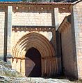
portal
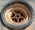
Rose window with pentagram

Capital with heads and diamonds


Web links
- Ucero, historical buildings - photos + information (Spanish)
- Ucero, castle - photos + information (spanish)
- Ucero, castle - video (spanish)
- Ucero, Ermita San Bartolomé - Photos + Info (Spanish)
- Ucero, Ermita San Bartolomé - Video (Spanish)
Individual evidence
- ↑ Cifras oficiales de población resultantes de la revisión del Padrón municipal a 1 de enero . Population statistics from the Instituto Nacional de Estadística (population update).
Abejar | Adradas | Ágreda | Alconaba | Alcubilla de Avellaneda | Alcubilla de las Peñas | Aldeal duck | Aldealices | Aldealpozo | Aldealseñor | Aldehuela de Periáñez | Las Aldehuelas | Alentisque | Aliud | Almajano | Almaluez | Almarza | Almazán | Almazul | Almenar de Soria | Alpanseque | Arancón | Arcos de Jalón | Arenillas | Arévalo de la Sierra | Ausejo de la Sierra | Baraona | Barca | Barcones | Bayubas de Abajo | Bayubas de Arriba | Beratón | Berlanga de Duero | Blacos | Bliecos | Borjabad | Borobia | Buberos | Buitrago | Burgo de Osma-Ciudad de Osma | Cabrejas del Campo | Cabrejas del Pinar | Calatañazor | Caltojar | Candilichera | Cañamaque | Carabantes | Caracena | Carrascosa de Abajo | Carrascosa de la Sierra | Casarejos | Castilfrío de la Sierra | Castillejo de Robledo | Castilruiz | Centenera de Andaluz | Cerbón | Cidones | Cigudosa | Cihuela | Ciria | Cirujales del Río | Coscurita | Covaleda | Cubilla | Cubo de la Solana | Cueva de Ágreda | Dévanos | Deca | Duruelo de la Sierra | Escobosa de Almazán | Espeja de San Marcelino | Espejón | Estepa de San Juan | Frechilla de Almazán | Fresno de Caracena | Fuentearmegil | Fuentecambrón | Fuentecantos | Fuentelmonge | Fuentelsaz de Soria | Fuentepinilla | Fuentes de Magaña | Fuentestrún | Garray | Golmayo | Gómara | Gormaz | Herrera de Soria | Hinojosa del Campo | Langa de Duero | Liceras | La Losilla | Magaña | Maján | Matalebreras | Matamala de Almazán | Medinaceli | Miño de Medinaceli | Miño de San Esteban | Molinos de Duero | Momblona | Monteagudo de las Vicarías | Montejo de Tiermes | Montenegro de Cameros | Morón de Almazán | Muriel de la Fuente | Muriel Viejo | Nafría de Ucero | Narros | Navaleno | Nepas | Nolay | Noviercas | Ólvega | Oncala | Pinilla del Campo | Portillo de Soria | La Póveda de Soria | Pozalmuro | Quintana Redonda | Quintanas de Gormaz | Quiñonería | Los Rábanos | Rebollar | Recuerda | Rello | Renieblas | Retortillo de Soria | Reznos | La Riba de Escalote | Rioseco de Soria | Rollamienta | El Royo | Balance | San Esteban de Gormaz | San Felices | San Leonardo de Yagüe | San Pedro Manrique | Santa Cruz de Yanguas | Santa María de Huerta | Santa María de las Hoyas | Serón de Nágima | Soliedra | Soria | Sotillo del Rincon | Suellacabras | Tajahuerce | Tajueco | Talveila | Tardelcuende | Taroda | Tejado | Torlengua | Torreblacos | Torrubia de Soria | Trévago | Ucero | Vadillo | Valdeavellano de Tera | Valdegeña | Valdelagua del Cerro | Valdemaluque | Valdenebro | Valdeprado | Valderrodilla | Valtajeros | Velamazán | Velilla de la Sierra | Velilla de los Ajos | Viana de Duero | Villaciervos | Villanueva de Gormaz | Villar del Ala | Villar del Campo | Villar del Río | Los Villares de Soria | Villasayas | Villaseca de Arciel | Vinuesa | Vizmanos | Vozmediano | Yanguas | Yelo