
Montejo de Tiermes
| Montejo de Tiermes municipality | |||
|---|---|---|---|
 Montejo de Tiermes - Landscape near the Ligos district
|
|||
| coat of arms | Map of Spain | ||
 Help on coat of arms |
|
||
| Basic data | |||
| Autonomous Community : |
|
||
| Province : | Soria | ||
| Comarca : | Comarca de Tiermes-Caracena | ||
| Coordinates | 41 ° 22 ′ N , 3 ° 12 ′ W | ||
| Height : | 1157 msnm | ||
| Area : | 167.27 km² | ||
| Residents : | 155 (Jan. 1, 2019) | ||
| Population density : | 0.93 inhabitants / km² | ||
| Postal code : | 42341, 42223 | ||
| Municipality number ( INE ): | 42120 | ||
| administration | |||
| Website : | Montejo de Tiermes | ||

Montejo de Tiermes is a municipality ( municipio ) with 155 inhabitants (as of January 1, 2019) in the northern Spanish province of Soria in the autonomous region of Castile-León .
Location and climate
Montejo de Tiermes lies at an altitude of about 1160 m . The next larger city, El Burgo de Osma , is about 38 km (driving distance) to the northeast. Up to the provincial capital Soria it is almost 100 km (driving distance) also in a northeast direction; on the way there is the listed town of Calatañazor . Also worth seeing are the listed places of San Esteban de Gormaz (approx. 27 km north), Ucero (approx. 55 km north) and Berlanga de Duero (approx. 40 km east). A 10 km hike in an easterly direction leads to the neighboring mountain village of Caracena . The climate is temperate to warm; Rain (approx. 530 mm / year) falls over the year.
Population development
| year | 1857 | 1900 | 1950 | 2000 | 2017 |
| Residents | 952 | 913 | 852 | 251 | 161 |
As a result of the mechanization of agriculture and the resulting lower demand for labor, the number of inhabitants has increased - despite the incorporation of the formerly independent villages Ligos, Torresuso, Cuevas de Ayllón, Noviales, Carrascosa de Arriba, Hoz de Abajo, Hoz de Arriba, Pedro, Rebollosa de Pedro and Valderromán - sharply declining since the middle of the 20th century.
economy
The small mountain village was and is largely characterized by agriculture (agriculture and cattle breeding). In earlier times, the place served as a handicraft and market center for the - meanwhile mostly abandoned - smaller farmhouses and hamlets in the area. Tourism (hiking and holiday apartments) has played an important role as a source of income for the community since the middle of the 20th century.
history
Findings suggest that a settlement called Termes or Termantia of the Celtiberian tribe of the Arevacians was in the immediate vicinity. The Romans were also in the area and left a spring enclosure in the place and a legionnaire's inscription in Noviales . The hermit church Ermita de la Virgen del Val in the district of Pedro is associated with the Visigoths . A watchtower ( atalaya ) from Islamic times at the entrance to the village reminds of the time of Islamic rule over large parts of the Iberian Peninsula , which in the northern part resulted in the defeat of the general Almansor in the summer of 1002 in the - historically not documented - battle of Calatañazor finally came to an end. Nothing is known about the affiliation of the place to late medieval and early modern manors .
Attractions


.jpg)
.jpg)
- Montejo de Tiermes
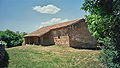
- At the entrance to Montejo de Tiermes there is a well-preserved watchtower ( Atalaya ) from the Islamic period, built on natural rock . Its entrance is - as usual - about 2.50 m high and could only be reached via a ladder (or rope ladder ).
- Two of the formerly six arcade arches of the Romanesque south porch ( portico ) of the Church of San Cornelio y San Cipriano are walled up. The only remaining capital rests - as usual - on a pair of double columns and shows two intertwined snakes. Inside the single-nave church there is a baroque altarpiece (retablo) .
- Most important is the hermit church (Ermita de Santa María) located a little outside the town , the arcades of which in the south porch (portico) are separated from one another by wall parts - a constellation that could point to an early construction period if there were not double columns with mature capitals next to it. These mainly show vegetable and abstract motifs; but also figurative themes (the fall of man and Daniel in the lions' den) can be seen. In contrast, the Romanesque portal is kept rather simple; in the archivolt there are a number of small rosettes. A side aisle has been added on the north side. The entire church is built from almost exactly hewn stones and so it is assumed that it was built in the late 12th century.
- The archaeological site of the Arevacian city of Termez is only 1 km away. There is also a small museum there (see web link).
- Pedro
- In the district of Pedro , a simple small church (Ermita de la Virgen del Val) has been preserved - possibly dating back to a previous Visigothic building. Later it was given a south porch resting on wooden pillars. Several ornamented stones set into the outer wall are reused ( spoilage ).
- Torresuso
- The small Romanesque church of Santa María Magdalena is optically enhanced by a south porch from the Renaissance period .
- Ligos
- The single-nave church of San Juan Bautista has a two-storey bell gable (espadaña) from the Renaissance above the otherwise unadorned west facade and an extraordinarily richly decorated Romanesque archivolt portal on the south side.
- Valderromán
- The place has a small late Gothic village church with a bell gable and a half-timbered bell chamber behind it, as well as an apse that was raised and enlarged in later times .
Ermita de la Virgen del Val in Pedro
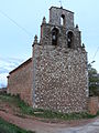
San Juan Bautista Church in Ligos - west facade with bell gable

Church of San Juan Bautista in Ligos - south portal

Valderromán Church


Web links
- Montejo de Tiermes, excavations etc. - Photos + information (Spanish)
- Tiermes, Ermita Santa María - Photos + Info (Spanish)
- Tiermes, Ermita Santa María - Photos + Info (Spanish)
- Tiermes, Ermita Santa María - Photos + Info (Spanish)
- Tiermes, Ermita Santa María - Photo
- Tiermes, Atalaya - Photos + Info (Spanish)
- Pedro, Ermita de la Virgen del Val - photos + information (spanish)
- Pedro, Ermita de la Virgen del Val - photo + information (Spanish)
- Catalog of churches with vestibules (Spanish)
Individual evidence
- ↑ Cifras oficiales de población resultantes de la revisión del Padrón municipal a 1 de enero . Population statistics from the Instituto Nacional de Estadística (population update).
- ↑ Montejo de Tiermes - climate tables
- ↑ Montejo de Tiermes - population development
Abejar | Adradas | Ágreda | Alconaba | Alcubilla de Avellaneda | Alcubilla de las Peñas | Aldeal duck | Aldealices | Aldealpozo | Aldealseñor | Aldehuela de Periáñez | Las Aldehuelas | Alentisque | Aliud | Almajano | Almaluez | Almarza | Almazán | Almazul | Almenar de Soria | Alpanseque | Arancón | Arcos de Jalón | Arenillas | Arévalo de la Sierra | Ausejo de la Sierra | Baraona | Barca | Barcones | Bayubas de Abajo | Bayubas de Arriba | Beratón | Berlanga de Duero | Blacos | Bliecos | Borjabad | Borobia | Buberos | Buitrago | Burgo de Osma-Ciudad de Osma | Cabrejas del Campo | Cabrejas del Pinar | Calatañazor | Caltojar | Candilichera | Cañamaque | Carabantes | Caracena | Carrascosa de Abajo | Carrascosa de la Sierra | Casarejos | Castilfrío de la Sierra | Castillejo de Robledo | Castilruiz | Centenera de Andaluz | Cerbón | Cidones | Cigudosa | Cihuela | Ciria | Cirujales del Río | Coscurita | Covaleda | Cubilla | Cubo de la Solana | Cueva de Ágreda | Dévanos | Deca | Duruelo de la Sierra | Escobosa de Almazán | Espeja de San Marcelino | Espejón | Estepa de San Juan | Frechilla de Almazán | Fresno de Caracena | Fuentearmegil | Fuentecambrón | Fuentecantos | Fuentelmonge | Fuentelsaz de Soria | Fuentepinilla | Fuentes de Magaña | Fuentestrún | Garray | Golmayo | Gómara | Gormaz | Herrera de Soria | Hinojosa del Campo | Langa de Duero | Liceras | La Losilla | Magaña | Maján | Matalebreras | Matamala de Almazán | Medinaceli | Miño de Medinaceli | Miño de San Esteban | Molinos de Duero | Momblona | Monteagudo de las Vicarías | Montejo de Tiermes | Montenegro de Cameros | Morón de Almazán | Muriel de la Fuente | Muriel Viejo | Nafría de Ucero | Narros | Navaleno | Nepas | Nolay | Noviercas | Ólvega | Oncala | Pinilla del Campo | Portillo de Soria | La Póveda de Soria | Pozalmuro | Quintana Redonda | Quintanas de Gormaz | Quiñonería | Los Rábanos | Rebollar | Recuerda | Rello | Renieblas | Retortillo de Soria | Reznos | La Riba de Escalote | Rioseco de Soria | Rollamienta | El Royo | Balance | San Esteban de Gormaz | San Felices | San Leonardo de Yagüe | San Pedro Manrique | Santa Cruz de Yanguas | Santa María de Huerta | Santa María de las Hoyas | Serón de Nágima | Soliedra | Soria | Sotillo del Rincon | Suellacabras | Tajahuerce | Tajueco | Talveila | Tardelcuende | Taroda | Tejado | Torlengua | Torreblacos | Torrubia de Soria | Trévago | Ucero | Vadillo | Valdeavellano de Tera | Valdegeña | Valdelagua del Cerro | Valdemaluque | Valdenebro | Valdeprado | Valderrodilla | Valtajeros | Velamazán | Velilla de la Sierra | Velilla de los Ajos | Viana de Duero | Villaciervos | Villanueva de Gormaz | Villar del Ala | Villar del Campo | Villar del Río | Los Villares de Soria | Villasayas | Villaseca de Arciel | Vinuesa | Vizmanos | Vozmediano | Yanguas | Yelo