Cigudosa
| Cigudosa municipality | ||
|---|---|---|
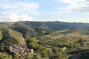
 Cigudosa - the townscape
|
||
| coat of arms | Map of Spain | |
 Help on coat of arms |
|
|
| Basic data | ||
| Autonomous Community : | Castile and Leon | |
| Province : | Soria | |
| Comarca : | Comarca del Moncayo | |
| Coordinates | 41 ° 56 ′ N , 2 ° 3 ′ W | |
| Height : | 735 msnm | |
| Area : | 21.03 km² | |
| Residents : | 19 (Jan. 1, 2019) | |
| Population density : | 0.9 inhabitants / km² | |
| Postal code : | 42113 | |
| Municipality number ( INE ): | 42062 | |
| administration | ||
| Website : | Cigudosa | |
Cigudosa is a place and a municipality ( municipio ) belonging to the poorly populated Serranía Celtibérica with only 19 permanent residents (January 1, 2019) in the province of Soria in the east of the autonomous community of Castile-León in Spain . Cigudosa is the lowest municipality in the entire province of Soria.
location
The place Cigudosa is located on a hill above a bend in the river Río Alhama approx. 59 km (driving distance) northeast of the provincial capital Soria near the border with the neighboring province La Rioja at an altitude of approx. 735 m ; to Logroño it is a good 100 km to the northwest. The climate is temperate to warm; Rain (approx. 515 mm / year) falls mainly in the winter half-year.
Population development
| year | 1857 | 1900 | 1950 | 2000 | 2018 |
| Residents | 355 | 316 | 454 | 76 | 18th |
As a result of the mechanization of agriculture , the abandonment of small farms and the resulting lower demand for labor, the number of inhabitants has declined significantly since the middle of the 20th century.
economy
The basis of the life and survival of the self-sufficient residents of Cigudosa was and is agriculture, which of course also includes cattle breeding. Some of the vacant houses have been converted into holiday apartments (casas rurales) in the last few decades .
history
Celts , Romans and Visigoths left no traces on the area of the municipality. A mighty defense and watchtower in the center of the village is said to date from the time of the Moors . The 11th century is characterized by the Christian reconquest ( reconquista ) and resettlement ( repoblación ) the area that until the Peace of Almazán equally from the (1375) Kingdom of Aragon and Castile was claimed.
Attractions
- From some of the quarry stones (mampostería) built and originally almost windowless defense tower is attributed to the Moorish period; others date it to Christian times. In the 18th or 19th century it was divided into five floors; larger windows were installed.
- Some of the one- and two-story older houses in the village also have stone facades.
- The parish church (Iglesia de San Pedro Apóstol) was originally a late Romanesque building with a bell gable (espadaña) . The entrance portal is on the south side; like the entire church, it was renewed in the 18th century and received a roofed porch. The church is single-nave; the crossing is topped by a dome with a lantern . The main altar (retablo) shows influences of the Churriguera style ; there are further altars on the side walls. The Romanesque baptismal font (pila bautismal) is also noteworthy .
Web links
- Cigudosa, tower - photo + info (Spanish)
- Cigudosa, tower and church - photo + info (Spanish)
- Cigudosa, church - photos + information (Spanish)
Individual evidence
- ↑ Cifras oficiales de población resultantes de la revisión del Padrón municipal a 1 de enero . Population statistics from the Instituto Nacional de Estadística (population update).
- ↑ Cigudosa - climate tables
- ^ Cigudosa - population development

