
Rello
| Rello municipality | |||
|---|---|---|---|
 Rello - location view
|
|||
| coat of arms | Map of Spain | ||
 Help on coat of arms |
|
||
| Basic data | |||
| Autonomous Community : |
|
||
| Province : | Soria | ||
| Comarca : | Comarca de Berlanga | ||
| Coordinates | 41 ° 20 ′ N , 2 ° 45 ′ W | ||
| Height : | 1075 msnm | ||
| Area : | 24.39 km² | ||
| Residents : | 14 (Jan. 1, 2019) | ||
| Population density : | 0.57 inhabitants / km² | ||
| Postal code : | 42368 | ||
| Municipality number ( INE ): | 42153 | ||
| administration | |||
| Website : | Rello | ||

Rello is a village and a municipality ( municipio ) with only 14 inhabitants (as of January 1, 2019) in the northern Spanish province of Soria in the autonomous community of Castile and León . The place surrounded by a city wall (muralla) is recognized as Conjunto histórico-artístico .
location
The place Rello is located on a hill above the Río Escalote a good 76 km (driving distance) southwest of the provincial capital Soria or almost 24 km southeast of Berlanga de Duero at an altitude of about 1075 m above sea level. d. The climate in winter is cool, but in summer it is quite warm; the rather low precipitation (approx. 515 mm / year) falls - with the exception of the rather poor summer months - distributed over the whole year.
Population development
| year | 1900 | 1950 | 2000 | 2016 |
| Residents | 242 | 252 | 42 | 17th |
The significant population decline in the 20th century is mainly due to the mechanization of agriculture and the associated loss of jobs.
economy
In antiquity and in the early Middle Ages, the high-altitude and therefore almost always green area was visited by shepherds with their goats and sheep in the summer months . In the Middle Ages, small traders, craftsmen and service providers of all kinds also settled in the predominantly agricultural and largely self-sufficient rural community. Since the 1970s, tourism in the form of renting holiday homes (casas rurales) has become the municipality's most important source of income.
history
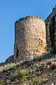
No news is known from ancient or early medieval times. At the end of the 11th century, the area was under Alfonso VI. recaptured by León (ruled 1065–1109) for the Christians ( reconquista ); the city wall (muralla) was built in the 14th century.
Attractions


- The entire place including its church is - like the city wall - built from rubble stones . House stones can only be found on the city gate, on the corner stones and door or window frames of some houses, on the base of the court column and on the bell gable of the church.
- The parish church (Iglesia de Nuestra Señora de la Asunción) , built around the middle of the 17th century, is dedicated to the Assumption of Mary . The bell gable (espadaña) , stabilized at the back by a bell housing, shows a change in color of the stone layers.
- A court column (rollo) or (picota) made from a cannon testifies to the sovereignty and civic pride of the community residents.

Castle gate with coat of arms

Ruin of the castle
Tower in front of the city wall

Court pillar (roller blind)


_1.jpg)
- Surroundings
- Approx. The Atalaya de Tiñon , a watchtower from Moorish times, rises 3 km north of the village .
- The interior of the Ermita de San Baudelio de Berlanga, which is decorated with Romanesque frescoes, is located approx. 20 km north of the village.
Web links
- Rello - photos + information (spanish)
- Rello - photos + information (spanish)
- Rello - photos + information (spanish)
- Rello - photos + information (spanish)
Individual evidence
- ↑ Cifras oficiales de población resultantes de la revisión del Padrón municipal a 1 de enero . Population statistics from the Instituto Nacional de Estadística (population update).
- ↑ Rello - Map with altitude information
- ↑ Rello - climate tables
- ↑ Rello - population development
- ↑ Rello - Atalaya de Tiñon
Abejar | Adradas | Ágreda | Alconaba | Alcubilla de Avellaneda | Alcubilla de las Peñas | Aldeal duck | Aldealices | Aldealpozo | Aldealseñor | Aldehuela de Periáñez | Las Aldehuelas | Alentisque | Aliud | Almajano | Almaluez | Almarza | Almazán | Almazul | Almenar de Soria | Alpanseque | Arancón | Arcos de Jalón | Arenillas | Arévalo de la Sierra | Ausejo de la Sierra | Baraona | Barca | Barcones | Bayubas de Abajo | Bayubas de Arriba | Beratón | Berlanga de Duero | Blacos | Bliecos | Borjabad | Borobia | Buberos | Buitrago | Burgo de Osma-Ciudad de Osma | Cabrejas del Campo | Cabrejas del Pinar | Calatañazor | Caltojar | Candilichera | Cañamaque | Carabantes | Caracena | Carrascosa de Abajo | Carrascosa de la Sierra | Casarejos | Castilfrío de la Sierra | Castillejo de Robledo | Castilruiz | Centenera de Andaluz | Cerbón | Cidones | Cigudosa | Cihuela | Ciria | Cirujales del Río | Coscurita | Covaleda | Cubilla | Cubo de la Solana | Cueva de Ágreda | Dévanos | Deca | Duruelo de la Sierra | Escobosa de Almazán | Espeja de San Marcelino | Espejón | Estepa de San Juan | Frechilla de Almazán | Fresno de Caracena | Fuentearmegil | Fuentecambrón | Fuentecantos | Fuentelmonge | Fuentelsaz de Soria | Fuentepinilla | Fuentes de Magaña | Fuentestrún | Garray | Golmayo | Gómara | Gormaz | Herrera de Soria | Hinojosa del Campo | Langa de Duero | Liceras | La Losilla | Magaña | Maján | Matalebreras | Matamala de Almazán | Medinaceli | Miño de Medinaceli | Miño de San Esteban | Molinos de Duero | Momblona | Monteagudo de las Vicarías | Montejo de Tiermes | Montenegro de Cameros | Morón de Almazán | Muriel de la Fuente | Muriel Viejo | Nafría de Ucero | Narros | Navaleno | Nepas | Nolay | Noviercas | Ólvega | Oncala | Pinilla del Campo | Portillo de Soria | La Póveda de Soria | Pozalmuro | Quintana Redonda | Quintanas de Gormaz | Quiñonería | Los Rábanos | Rebollar | Recuerda | Rello | Renieblas | Retortillo de Soria | Reznos | La Riba de Escalote | Rioseco de Soria | Rollamienta | El Royo | Balance | San Esteban de Gormaz | San Felices | San Leonardo de Yagüe | San Pedro Manrique | Santa Cruz de Yanguas | Santa María de Huerta | Santa María de las Hoyas | Serón de Nágima | Soliedra | Soria | Sotillo del Rincon | Suellacabras | Tajahuerce | Tajueco | Talveila | Tardelcuende | Taroda | Tejado | Torlengua | Torreblacos | Torrubia de Soria | Trévago | Ucero | Vadillo | Valdeavellano de Tera | Valdegeña | Valdelagua del Cerro | Valdemaluque | Valdenebro | Valdeprado | Valderrodilla | Valtajeros | Velamazán | Velilla de la Sierra | Velilla de los Ajos | Viana de Duero | Villaciervos | Villanueva de Gormaz | Villar del Ala | Villar del Campo | Villar del Río | Los Villares de Soria | Villasayas | Villaseca de Arciel | Vinuesa | Vizmanos | Vozmediano | Yanguas | Yelo