
Golmayo (Soria)
| Golmayo municipality | |||
|---|---|---|---|
 Golmayo-Fuentetoba - Monasterio de la Monjía
|
|||
| coat of arms | Map of Spain | ||
 Help on coat of arms |
|
||
| Basic data | |||
| Autonomous Community : |
|
||
| Province : | Soria | ||
| Comarca : | Comarca de Soria | ||
| Coordinates | 41 ° 46 ′ N , 2 ° 31 ′ W | ||
| Height : | 1040 msnm | ||
| Area : | 189.83 km² | ||
| Residents : | 2,626 (Jan 1, 2019) | ||
| Population density : | 13.83 inhabitants / km² | ||
| Postal code : | 42190 | ||
| Municipality number ( INE ): | 42095 | ||
| administration | |||
| Website : | Golmayo | ||

Golmayo is a place and one from the main village and several hamlets (Pedanías) and individual farms (fincas) existing northern Spanish municipality ( municipio ) with a total of 2,626 inhabitants (at January 1, 2019) in the province of Soria of the Autonomous Community of Castile and Leon . The parish belongs to the Diocese of Osma-Soria .
Location and climate
The approximately 190 km² large community Golmayo is located on the Río Golmayo , a small tributary of the Duero , about 5 to 15 km (driving distance) west of the provincial capital Soria at an average altitude of about 1040 m . The climate is harsh in winter, but temperate to warm in summer; Rain (approx. 555 mm / year) falls over the year.
Population development
At the end of the 20th and the beginning of the 21st century, the new housing estate Camaretas with around 1,500 inhabitants was built in the area of the municipality of Golmayo ; At the same time, the previously independent municipalities of Camparañón, Carbonera de Frentes, La Cuenca, Las Fraguas, Fuentetoba, La Mallona, La Muela, Nafría la Llana, Nódalo and Villabuena were gradually incorporated, as a result of which the municipality, which is close to the provincial capital of Soria, experienced an enormous population increase.
economy
The community is traditionally oriented towards agriculture (grain, sunflowers ); cattle breeding is also practiced. In the past, people lived largely as self-sufficient ; today it is mainly produced for urban markets.
history
The Celts , Romans and Visigoths left no archaeological traces. In the 8th century the Moors penetrated into the region and were only pushed back in the 11th century ( reconquista ) . Then Christians from the north and south of the Iberian Peninsula settled here ( repoblación ) .
Attractions
- The Benedictine monastery of La Monjía , located near the source of the Río Golmayo, was built in the 11th century; later it was repeatedly changed and in the 16th century it was walled by the Counts of Castejón.
- The late Gothic church of Nuestra Señora de la Asunción in Golmayo dates from around 1500.
- Almost every village belonging to the municipality has its own small church or chapel.
- A “Roman bridge” probably dating from the Middle Ages crosses the Río Golmayo ; Another bridge is near Camparañón .
- Some hermit churches (ermitas) are also scattered across the parish.
- A new church has been built in the Camaretas settlement .

Las Fraguas - Santuario de la Virgen de Inodejo

Nafria la Llana - Iglesia de la Natividad
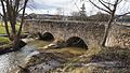
"Roman Bridge" (puente romano) near Golmayo


Web links
- Golmayo - Photos and information (Spanish)
- Golmayo, sights - photos and information (Spanish)
Individual evidence
- ↑ Cifras oficiales de población resultantes de la revisión del Padrón municipal a 1 de enero . Population statistics from the Instituto Nacional de Estadística (population update).
- ↑ Golmayo - climate tables
Abejar | Adradas | Ágreda | Alconaba | Alcubilla de Avellaneda | Alcubilla de las Peñas | Aldeal duck | Aldealices | Aldealpozo | Aldealseñor | Aldehuela de Periáñez | Las Aldehuelas | Alentisque | Aliud | Almajano | Almaluez | Almarza | Almazán | Almazul | Almenar de Soria | Alpanseque | Arancón | Arcos de Jalón | Arenillas | Arévalo de la Sierra | Ausejo de la Sierra | Baraona | Barca | Barcones | Bayubas de Abajo | Bayubas de Arriba | Beratón | Berlanga de Duero | Blacos | Bliecos | Borjabad | Borobia | Buberos | Buitrago | Burgo de Osma-Ciudad de Osma | Cabrejas del Campo | Cabrejas del Pinar | Calatañazor | Caltojar | Candilichera | Cañamaque | Carabantes | Caracena | Carrascosa de Abajo | Carrascosa de la Sierra | Casarejos | Castilfrío de la Sierra | Castillejo de Robledo | Castilruiz | Centenera de Andaluz | Cerbón | Cidones | Cigudosa | Cihuela | Ciria | Cirujales del Río | Coscurita | Covaleda | Cubilla | Cubo de la Solana | Cueva de Ágreda | Dévanos | Deca | Duruelo de la Sierra | Escobosa de Almazán | Espeja de San Marcelino | Espejón | Estepa de San Juan | Frechilla de Almazán | Fresno de Caracena | Fuentearmegil | Fuentecambrón | Fuentecantos | Fuentelmonge | Fuentelsaz de Soria | Fuentepinilla | Fuentes de Magaña | Fuentestrún | Garray | Golmayo | Gómara | Gormaz | Herrera de Soria | Hinojosa del Campo | Langa de Duero | Liceras | La Losilla | Magaña | Maján | Matalebreras | Matamala de Almazán | Medinaceli | Miño de Medinaceli | Miño de San Esteban | Molinos de Duero | Momblona | Monteagudo de las Vicarías | Montejo de Tiermes | Montenegro de Cameros | Morón de Almazán | Muriel de la Fuente | Muriel Viejo | Nafría de Ucero | Narros | Navaleno | Nepas | Nolay | Noviercas | Ólvega | Oncala | Pinilla del Campo | Portillo de Soria | La Póveda de Soria | Pozalmuro | Quintana Redonda | Quintanas de Gormaz | Quiñonería | Los Rábanos | Rebollar | Recuerda | Rello | Renieblas | Retortillo de Soria | Reznos | La Riba de Escalote | Rioseco de Soria | Rollamienta | El Royo | Balance | San Esteban de Gormaz | San Felices | San Leonardo de Yagüe | San Pedro Manrique | Santa Cruz de Yanguas | Santa María de Huerta | Santa María de las Hoyas | Serón de Nágima | Soliedra | Soria | Sotillo del Rincon | Suellacabras | Tajahuerce | Tajueco | Talveila | Tardelcuende | Taroda | Tejado | Torlengua | Torreblacos | Torrubia de Soria | Trévago | Ucero | Vadillo | Valdeavellano de Tera | Valdegeña | Valdelagua del Cerro | Valdemaluque | Valdenebro | Valdeprado | Valderrodilla | Valtajeros | Velamazán | Velilla de la Sierra | Velilla de los Ajos | Viana de Duero | Villaciervos | Villanueva de Gormaz | Villar del Ala | Villar del Campo | Villar del Río | Los Villares de Soria | Villasayas | Villaseca de Arciel | Vinuesa | Vizmanos | Vozmediano | Yanguas | Yelo