Suellacabras
| Suellacabras municipality | ||
|---|---|---|
| coat of arms | Map of Spain | |
 Help on coat of arms |
|
|
| Basic data | ||
| Autonomous Community : | Castile and Leon | |
| Province : | Soria | |
| Coordinates | 41 ° 51 ′ N , 2 ° 13 ′ W | |
| Height : | 1182 msnm | |
| Area : | 39.19 km² | |
| Residents : | 25 (Jan. 1, 2019) | |
| Population density : | 0.64 inhabitants / km² | |
| Municipality number ( INE ): | 42175 | |
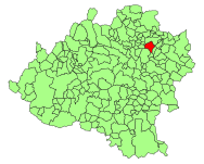
| Location of the municipality | ||

|
||
Suellacabras is a municipality with 25 inhabitants located in the Sierra del Almuerzo northeast of the provincial capital Soria in Castile-León in Spain (as of January 1, 2019).
The Soriano river, which flows into the Ebro , has its source in the local thermal spring Alhama ("al-hamma") .
San Caprasio is a nearby hermitage with a stele in the forecourt . This is attributed the ability to create lasting connections. A cyclopean wall ring five meters high, which was found in the remains of a house from the late Iron Age , belongs to the Los Castillares (Castros Sorianos) of this area. There is also a Visigoth necropolis with finds of fibulae , glasses, weapons and an "Osculatorios", a ring with a dove (as a symbol of the Holy Spirit), which was used by the Arian Goths for blessing.
Individual evidence
- ↑ Cifras oficiales de población resultantes de la revisión del Padrón municipal a 1 de enero . Population statistics from the Instituto Nacional de Estadística (population update).
literature
- Max-Otto Hermann: Temple, cult and ruin sites - ground monuments from early and ancient times . Gebrüder Mann, Berlin 1995, ISBN 3-7861-1824-8 , p. 349.
