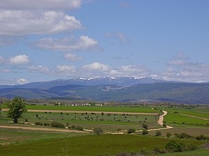
Pico de Urbión
| Pico de Urbión | ||
|---|---|---|
|
Chain of the Picos de Urbión |
||
| height | 2228 msnm | |
| location | Castile , La Rioja, Spain | |
| Mountains | Picos de Urbión | |
| Coordinates | 42 ° 0 '41 " N , 2 ° 52' 43" W | |
|
|
||

The 2,228-meter-high Pico de Urbión is the highest peak of the mountain range of the same name of the Picos de Urbión , part of the north of Spain located Iberian mountains .
location
The Pico Urbión forms the border point between the Spanish provinces of Burgos , Soria and La Rioja . It is located about 10 km (as the crow flies) north of the town of Covaleda in the province of Soria .
Rivers
The Picos de Urbión form an important watershed on the Iberian Peninsula : the Duero River , one of the longest rivers on the Iberian Peninsula , rises on the southern slope and ultimately flows into the Atlantic Ocean . On the northwest side there are three small mountain lakes (lagunas) from which the Río Urbión rises, whose waters flow over the Ebro into the Mediterranean .
Ascent
From the south (Covaleda) or from the south-east ( Laguna Negra ) hiking trails lead up to an altitude of around 1800 m. With suitable footwear, it is possible to climb the summit in good weather.
Web links
- Pico Urbión - topographic map + info (English)
- Pico Urbión - topographic map, photos + info (Spanish)

