Hammerbach (Modau)
| Hammerbach | ||
|
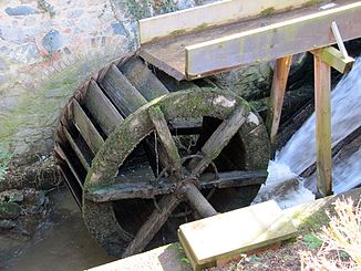
Hammerbach an der Hammermühle (2010) |
||
| Data | ||
| Water code | DE : 239623316 | |
| location |
Odenwald
|
|
| River system | Rhine | |
| Drain over | Modau → Rhine → North Sea | |
| Branch at the weir | in Ober-Ramstadt in the Odenwald 49 ° 49 ′ 24 ″ N , 8 ° 44 ′ 49 ″ E |
|
| muzzle | in Ober-Ramstadt in the Modau coordinates: 49 ° 49 ′ 45 " N , 8 ° 44 ′ 48" E 49 ° 49 ′ 45 " N , 8 ° 44 ′ 48" E
|
|
| length | 400 m | |
The Hammerbach is an approximately 650 m long Mühlkanal to the left of the Modau , which flows through Ober-Ramstadt in the Hessian district of Darmstadt-Dieburg .
geography
course
The Hammerbach runs in the Vorderen Odenwald and in the Bergstrasse-Odenwald Nature Park . It branches off from the Modau in the southern urban area of Ober-Ramstadt and flows northwards. In the center of Ober-Ramstadt the Hammerbach flows from the left into the Modau Rhine tributary .
Only the 400 m long upper trench above and south of the hammer mill is used as surface water (DLM25) .
Mill and Etymology
The Hammermühle is located on Hammerbach, right next to the town hall of Ober-Ramstadt. The name Hammerbach probably refers to the hammer mill.
Individual evidence
- ↑ WFD kilometrage
