Hans Frese
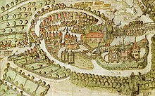
Hans Frese (also: Hanß Freese , * around 1527; † 1608) was an artillery master ("artolereymeister") and master's degree (1605) of the Bergedorf Castle and a German cartographer. Some cartographic images are attributed to him.
Life
As an artillery master, Frese was responsible for the maintenance of the defenses and the armament of the Bergedorf Castle, as well as monitoring the ammunition stocks. In addition, as an engineer officer, he was entrusted with land surveying tasks, the results of which he implemented in his maps.
Works
- A monochrome map of Bergedorf from October 16, 1593
- A demolition of the Thiergarten in the Abbedei zum Reinfelde signed with Hansen Fresan in 1595, a copy hangs in the Heimatmuseum in Reinfeld (Holstein) .
- A colored map of Bergedorf , which is now in the Hamburg State Archives, is referred to as the "Outline of the area around Bergedorf from 1598".
- A map showing the course of the Wakenitz from Ratzeburger See to Lübeck from 1605, with a few marginal notes mainly of historical content. The original, which was several cubits long, was still in Lübeck in 1860, a four times smaller copy was still in the Kiel University Library in 1916.
- A map of the lock ditch, dated 1610, shows the landscape between Neuengamme and Reinbek. The map contains the first known representation of the village of Lohbrügge.
literature
- Yearbook for regional studies of the duchies of Schleswig-Holstein and Lauenburg , III (1860) 319,
- Harry Schmidt : Frese, Hans . In: Ulrich Thieme (Hrsg.): General Lexicon of Fine Artists from Antiquity to the Present . Founded by Ulrich Thieme and Felix Becker . tape 12 : Fiori-Fyt . EA Seemann, Leipzig 1916, p. 409 ( Textarchiv - Internet Archive ).
- Lichtwark , No. 8, 1st year, July 1949. Ed. Lichtwark Committee, Bergedorf
- Lichtwark , No. 41, December 1978. Ed. Lichtwark Committee, Bergedorf
- Lichtwark , No. 70, 58th year, December 2005. Verlag HB-Werbung, Hamburg-Bergedorf. ISSN 1862-3549 .
- Public Library Hamburg Cbk-102-c (Bergedorf Heft)
Individual evidence
- ↑ a b Gerd Hoffmann (Ed.): Hamburg in historical maps: 1528 to 1920 . 1st edition. Sutton, Erfurt 2009, ISBN 978-3-86680-526-2 , p. 24, 29 .
- ↑ Ludwig Uphoff: Map of Bergedorf by Hanß Frese, artolereymeister - recognized anno 1593, October 16th . In: Lichtwark No. 23. Ed. Bergedorf District Office, Bergedorf, 1962. See now: Verlag HB-Werbung, Hamburg-Bergedorf. ISSN 1862-3549 .
| personal data | |
|---|---|
| SURNAME | Frese, Hans |
| BRIEF DESCRIPTION | German cartographer |
| DATE OF BIRTH | around 1527 |
| DATE OF DEATH | 1608 |
