Harilaid (peninsula)
| Harilaid | ||
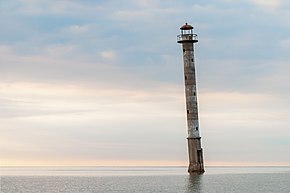
 Kiipsaare lighthouse before erection |
||
| Geographical location | ||
|
|
||
| Coordinates | 58 ° 29 ′ 0 ″ N , 21 ° 51 ′ 0 ″ E | |
| Waters 1 | Baltic Sea | |
| surface | 4 km² | |
Harilaid is a peninsula (Estonian poolsaar) in the rural municipality of Saaremaa in the Saare district on the largest Estonian island of Saaremaa .
It has an area of around 4 km² and is connected to Saaremaa by a natural isthmus that is around 300 m wide. Until the 17th century, Harilaid was a barrier island. The Kiipsaare tuletorn lighthouse is located on the peninsula .
On the peninsula are the 64 hectare Laialepa laht lake and the 4.1 hectare Pihelpuuauk lake .
Web links
Commons : Harilaid - collection of images, videos and audio files
