Haurup
|
Haurup
Handewitt parish
Coordinates: 54 ° 43 ′ 37 ″ N , 9 ° 20 ′ 49 ″ E
|
||
|---|---|---|
| Postal code : | 24983 | |
| Area code : | 04608 | |
|
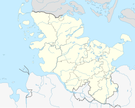
Location of Haurup in Schleswig-Holstein |
||
Haurup ( Danish : Havrup ) is a district of the municipality of Handewitt .
location
The neighboring village of Hüllerup is located seven hundred meters north of Haurup . To the north, beyond the nearby Handewitter Forest , the main town of Handewitt is four kilometers away. The main town of the municipality can be reached from the village of Haurup via Landstrasse 96 (L 96). The northeastern city of Flensburg is also about four kilometers from the village of Haurup. The village of Barderup is also two kilometers south-east .
history
The village was first mentioned in 1472 under the name "Haudorpp" in the feudal register. The first place name component "Hau" or Danish "Hav" is derived from the plant name old Danish "hafri" for oats ( New Danish havre , meaning in German would be oat village ), from the personal name Hafri, which in turn goes back to "hafri" for oats or possibly from the old Danish word "Haghi" which had the meaning "enclosure" and the etymologically related Danish word "Have" which means garden . The ending - rup of today's common place name is a synonym for a " village ". According to the last-mentioned attempt at interpretation, the place name would describe the then closed appearance of the village.
In the 15th century and into the 17th century, Haurup consisted of six farms. By dividing farms, the number increased to twelve by 1730. In 1806 the coupling was carried out. Haurup with his houses and courtyards could be recognized on the land survey of the Scientific Society of Denmark from 1857/1858 as well as on the map of the Prussian land survey around 1879 . From 1960 to about 1980 the land consolidation took place . At that time the road connection L 96 to Hüllerup was built. The Hügelweg was built around 1970 and 12 houses were built there. In the course of the dissolution of the Flensburg-Land district in 1974, the previously independent municipality of Haurup, together Ellund, Gottrupel, Hüllerup and Timmersiek, was incorporated into Handewitt.
Individual evidence
- ↑ Info banner: Handewitt municipality. Handewitt. Ellund. Gottruple. Hüllerup. Haurup. Jarplund. Timmersiek. Weding , accessed on: July 10, 2020
- ↑ Handewitt community development - compilation of projects , from: July 11, 2020
- ↑ Anders Bjerrum: Sydslesvigs Stednavne , Vol. 4, 1979–1986, p. 187
- ↑ Wolfgang Laur: Historisches Ortsnamelexikon von Schleswig-Holstein , 2nd edition, Neumünster 1992, p. 314
- ↑ Wolfgang Laur: Historisches Ortsnamelexikon von Schleswig-Holstein , 2nd edition, Neumünster 1992, p. 314
- ↑ Handewitt municipality (ed.): Official Chronicle Handewitt , Handewitt 2013, p. 665
- ↑ Cf. also the word village with regard to the meaning of -rup: Danish : torp, Low German : Dbod, Dorp, English also: thorp (e); See Flensburg street names . Society for Flensburg City History, Flensburg 2005, article: Tremmerupweg and Wolfgang Lindow: Low German dictionary. Schuster, Leer 1998, article: Dorf and Judy Persall: The New Oxford Dictionary of English , 2001, article: thorpe
- ↑ Handewitt municipality (ed.): Official Chronicle Handewitt , Handewitt 2013, p. 665
- ^ General letters Videnskabernes Selskab Kaart over Slesvig, Vestre Blad (3). Copenhagen Royal Library.Retrieved July 11, 2020 .
- ↑ Prussian land survey around 1879 , accessed on: March 8, 2020
- ↑ Handewitt municipality (ed.): Official Chronicle Handewitt , Handewitt 2013, p. 665
