
Hausener wall
| Hausener wall | ||
|---|---|---|
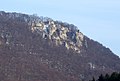
 Landslide area of the Hausener Wand |
||
| height | 250 m | |
| location | Baden-Wuerttemberg , Germany | |
| Mountains | Swabian Alb | |
| Coordinates | 48 ° 36 '38 " N , 9 ° 46' 26" E | |
|
||

The Hausener Wand is a rock face on a "Auslieger" that protrudes 250 meters above the valley floor in the Upper Filstal, east of the village of Hausen an der Fils, which belongs to Bad Überkingen .
History and geology
The Hausener Wall was probably created by a landslide at the end of the last Ice Age. At the foot of the wall you can still see the slipped rock and rubble.
The demolition wall provides an insight into the structure of the White Jura . The Tübingen geologist Friedrich August von Quenstedt called it a "geological window". In the times of the Jurassic Sea, it was part of a huge reef. The alternation of the limestone and marl in the Weißjura Gamma and the onset of the sponging in the Weißjura Delta are clearly visible on the wall. Layers of the White Jurassic Alpha can still be seen in the lower area.
At the edge of the Hausener Wall, it is possible to climb to a viewing platform, from which there is a view over Hausen an der Fils and the Upper Filstal.
Protected areas
In 1971 the Hausener Wall was placed under nature protection, the reserve covers 77.6 hectares. The supplementary landscape protection area has a size of 16 hectares. Part of the area also belongs to the transnational Natura 2000 protected area system .
The rock face is also protected as a geotope under the name Hausener Wand E above Hausen an der Fils .
gallery

View from the Bad Überkingen waterworks
eastern rock formation

Hausener Felsen, drawing by Margret Hofheinz-Döring


See also
Alte Hausener Wand, a climbing rock near Hausen im Tal in the upper Danube valley , not to be confused with the Hausener Wand in Filstal.
Web links
- Geotopes profile. (PDF; 618 KB) published as geotope no. 6877/1156. State Office for Geology, Raw Materials and Mining (LGRB), November 22, 2016.